IMAGES TAKEN NEAR TO
Gregory Park North, CB5 8LQ
Introduction
This page details the photographs taken nearby to Gregory Park North, CB5 8LQ by members of the Geograph project.
The Geograph project started in 2005 with the aim of publishing, organising and preserving representative images for every square kilometre of Great Britain, Ireland and the Isle of Man.

There are currently over 7.5m images from over14,400 individuals and you can help contribute to the project by visiting https://www.geograph.org.uk
Image Map
Images are licensed for reuse under creativecommons.org/licenses/by-sa/2.0
Notes
- Clicking on the map will re-center to the selected point.
- The higher the marker number, the further away the image location is from the centre of the postcode.
Image Listing (68 Images Found)
Images are licensed for reuse under creativecommons.org/licenses/by-sa/2.0
Image
Details
Distance
1
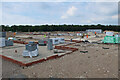
Marleigh development, Cambridge
A significant expansion of Cambridge. See Image for a photo of the area as farmland.
Image: © Hugh Venables
Taken: 7 Jun 2021
0.01 miles
3
Cambridge Jubilee Cycleway
Part of national cycle route 51.
Image: © Hugh Venables
Taken: 7 Dec 2014
0.03 miles
4
Marleigh development
A significant expansion of Cambridge. See Image for a photo of the area as farmland.
Image: © Hugh Venables
Taken: 7 Jun 2021
0.04 miles
5
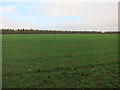
Field near Fen Ditton
On the list for the continued expansion of Cambridge.
Image: © Hugh Venables
Taken: 7 Dec 2014
0.04 miles
6
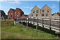
Bridge over a swale, Marleigh development
Image: © Hugh Venables
Taken: 21 Jun 2023
0.06 miles
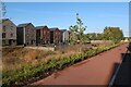
7
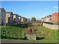
Gregory Park South and North
South on the left, North on the right. This is part of the large new Marleigh estate off Newmarket Road on the edge of Cambridge.
Image: © John Sutton
Taken: 16 Feb 2024
0.07 miles
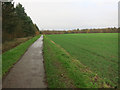
9
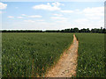
Footpath to Teversham
The well-defined path from Fen Ditton, viewed from the edge of the plantation to the south of the former course of the Cambridge to Mildenhall railway. Much of the wheatfield is in the next gridsquare to the east. With no discernible rain from February to May 2010, Cambridgeshire is one of five eastern counties officially designated drought areas, as the dry and cracked path shows.
Image: © John Sutton
Taken: 14 Jun 2011
0.08 miles
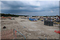
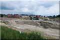
10
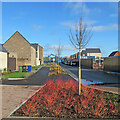
Building continues at Marleigh
This is a large new housing estate north of Newmarket Road, on the edge of Cambridge.
Image: © John Sutton
Taken: 16 Feb 2024
0.09 miles