IMAGES TAKEN NEAR TO
Marleigh Avenue, CAMBRIDGE, CB5 8BX
Introduction
This page details the photographs taken nearby to Marleigh Avenue, CB5 8BX by members of the Geograph project.
The Geograph project started in 2005 with the aim of publishing, organising and preserving representative images for every square kilometre of Great Britain, Ireland and the Isle of Man.

There are currently over 7.5m images from over14,400 individuals and you can help contribute to the project by visiting https://www.geograph.org.uk
Image Map
Images are licensed for reuse under creativecommons.org/licenses/by-sa/2.0
Notes
- Clicking on the map will re-center to the selected point.
- The higher the marker number, the further away the image location is from the centre of the postcode.
Image Listing (91 Images Found)
Images are licensed for reuse under creativecommons.org/licenses/by-sa/2.0
Image
Details
Distance
1
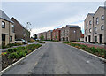
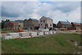
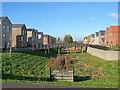
On Marleigh Avenue
This new estate north of Newmarket Road is being developed by Marshall of Cambridge and the builder Hill. When complete it will have shops and a primary school.
Image: © John Sutton
Taken: 3 Oct 2021
0.01 miles
3
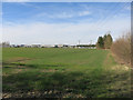
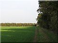
Field on the edge of Cambridge
Looking towards the Marshall site.
Image: © Hugh Venables
Taken: 5 Mar 2015
0.05 miles
4
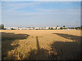
Edge of Cambridge
Wheat field by Marshall's site.
Image: © Hugh Venables
Taken: 15 Jul 2011
0.06 miles
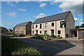
5
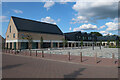
Marleigh Primary Academy
Primary schools are generally added very early to new developments.
Image: © Hugh Venables
Taken: 21 Jun 2023
0.07 miles
7
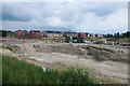
Marleigh development, Cambridge
A significant expansion of Cambridge. See Image for a photo of the area as farmland.
Image: © Hugh Venables
Taken: 7 Jun 2021
0.07 miles
8
Path to Fen Ditton
This path links Newmarket Road (behind the camera) and the east end of Fen Ditton. The line of trees in the distance borders the old Cambridge-Mildenhall railway, which closed in 1964. That part of it is now a permissive path, which this footpath crosses.
Image: © John Sutton
Taken: 23 Oct 2011
0.07 miles
9
Gregory Park South and North
South on the left, North on the right. This is part of the large new Marleigh estate off Newmarket Road on the edge of Cambridge.
Image: © John Sutton
Taken: 16 Feb 2024
0.09 miles
10
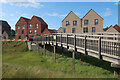
Bridge over a swale, Marleigh development
Image: © Hugh Venables
Taken: 21 Jun 2023
0.09 miles