IMAGES TAKEN NEAR TO
Sturmer Close, CAMBRIDGE, CB4 3XN
Introduction
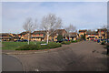
This page details the photographs taken nearby to Sturmer Close, CB4 3XN by members of the Geograph project.
The Geograph project started in 2005 with the aim of publishing, organising and preserving representative images for every square kilometre of Great Britain, Ireland and the Isle of Man.

There are currently over 7.5m images from over14,400 individuals and you can help contribute to the project by visiting https://www.geograph.org.uk
Image Map
Images are licensed for reuse under creativecommons.org/licenses/by-sa/2.0
Notes
- Clicking on the map will re-center to the selected point.
- The higher the marker number, the further away the image location is from the centre of the postcode.
Image Listing (185 Images Found)
Images are licensed for reuse under creativecommons.org/licenses/by-sa/2.0
Image
Details
Distance
1
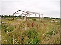
Former bus depot, Kings Hedges Road, Cambridge
Still marked as a bus depot on the 1:25000 map, but it looks pretty far gone to me. UPDATE (October 2005): construction has just started on a new housing development on this site, but the picture in the Cambridge Weekly News still shows this structure standing.
Image: © David Gruar
Taken: 31 Jul 2005
0.02 miles