IMAGES TAKEN NEAR TO
Frenchs Road, CAMBRIDGE, CB4 3LB
Introduction
This page details the photographs taken nearby to Frenchs Road, CB4 3LB by members of the Geograph project.
The Geograph project started in 2005 with the aim of publishing, organising and preserving representative images for every square kilometre of Great Britain, Ireland and the Isle of Man.

There are currently over 7.5m images from over14,400 individuals and you can help contribute to the project by visiting https://www.geograph.org.uk
Image Map (Loading...)


Getting Data...Please wait
Leaflet Map data © OpenStreetMap
Images are licensed for reuse under creativecommons.org/licenses/by-sa/2.0
Notes
- Clicking on the map will re-center to the selected point.
- The higher the marker number, the further away the image location is from the centre of the postcode.
Image Listing (229 Images Found)
Images are licensed for reuse under creativecommons.org/licenses/by-sa/2.0
Image
Details
Distance
2
French's Mill
Also known as Chesterton Mill, this smock mill, now devoid of its sails, is hidden away at the end of French's Road. It is the last surviving windmill in the city, though there are three just beyond the boundary at:
Fulbourn Image
Impington Image
Madingley Image).
The maltster William Beart built the mill in 1847, but sadly died shortly afterwards. William French then acquired a lease on the property and in 1850 was able to buy the freehold (including a granary, stables, a cottage for the miller and half an acre of ground) at public auction for £440. The mill was successively converted to steam, gas and finally diesel power but continued to grind corn until 1956, and the buildings were converted into offices during the early 1980s.
For a closer view of the tower with its brick base see Image French's Mill is listed Grade II https://britishlistedbuildings.co.uk/101337012-windmill-at-chesterton-mills-cambridge
Chesterton Mill website https://www.chestertonmill.com/
Image: © Tiger
Taken: 6 Jul 2007
0.05 miles
3
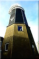
Chesterton Mill
The tower of William French's mid-19th century smock mill, with its octagonal brick base, weatherboarded upper stage and white sailless cap, still forms an attractive centrepiece for the complex of new and restored buildings on the Chesterton Mill site. See Image for more detailed history.
Image: © Tiger
Taken: 9 Nov 2021
0.05 miles
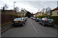
4
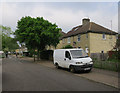
Along Harvey Goodwin Avenue
Twentieth-century houses and a bungalow in a northern suburb of Cambridge.
Image: © John Sutton
Taken: 19 Apr 2021
0.06 miles
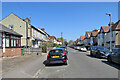
5
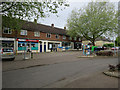
Shops on Akeman Street
There are plans to redevelop the row of shops and flats.
Image: © Hugh Venables
Taken: 13 May 2016
0.08 miles
6

Shop and Community Rooms on Akeman Street
There are plans to redevelop the row of shops and flats.
Image: © Hugh Venables
Taken: 13 May 2016
0.08 miles
8
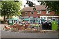
Akeman Street party
Cambridge City Council sponsored the afternoon event on a wildlife theme, with food and music, outside the community rooms.
Image: © Tiger
Taken: 23 Jul 2016
0.09 miles
9

Good Sounds
Members of the local community singing group entertain at the free street party in Akeman Street sponsored by Cambridge City Council.
Image: © Tiger
Taken: 23 Jul 2016
0.09 miles
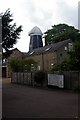
10
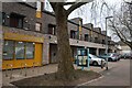
Akeman Community Centre
See Image for a view before the redevelopment.
Image: © Hugh Venables
Taken: 24 Dec 2023
0.09 miles