IMAGES TAKEN NEAR TO
Sweetpea Way, CAMBRIDGE, CB4 2ZA
Introduction
This page details the photographs taken nearby to Sweetpea Way, CB4 2ZA by members of the Geograph project.
The Geograph project started in 2005 with the aim of publishing, organising and preserving representative images for every square kilometre of Great Britain, Ireland and the Isle of Man.

There are currently over 7.5m images from over14,400 individuals and you can help contribute to the project by visiting https://www.geograph.org.uk
Image Map (Loading...)


Getting Data...Please wait
Leaflet Map data © OpenStreetMap
Images are licensed for reuse under creativecommons.org/licenses/by-sa/2.0
Notes
- Clicking on the map will re-center to the selected point.
- The higher the marker number, the further away the image location is from the centre of the postcode.
Image Listing (290 Images Found)
Images are licensed for reuse under creativecommons.org/licenses/by-sa/2.0
Image
Details
Distance
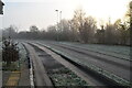
1
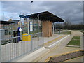
Orchard Park: The Cambridgeshire Guided Busway
This is the mothballed northbound Orchard Park West guided bus stop looking in the direction of St Ives. In the lower right of the photograph is one of the car traps, gravel filled pits designed to prevent non-bus traffic from using the busway.
Image: © Nigel Cox
Taken: 5 Feb 2011
0.02 miles