IMAGES TAKEN NEAR TO
Starr End, CAMBRIDGE, CB4 2WN
Introduction
This page details the photographs taken nearby to Starr End, CB4 2WN by members of the Geograph project.
The Geograph project started in 2005 with the aim of publishing, organising and preserving representative images for every square kilometre of Great Britain, Ireland and the Isle of Man.

There are currently over 7.5m images from over14,400 individuals and you can help contribute to the project by visiting https://www.geograph.org.uk
Image Map (137 Images)


Getting Data...Please wait
Leaflet Map data © OpenStreetMap
Images are licensed for reuse under creativecommons.org/licenses/by-sa/2.0
Notes
- Clicking on the map will re-center to the selected point.
- The higher the marker number, the further away the image location is from the centre of the postcode.
Image Listing (137 Images Found)
Images are licensed for reuse under creativecommons.org/licenses/by-sa/2.0
Image
Details
Distance
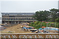
8
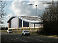
Arbury Grid Substation - completed
The final form of the building seen going up in Image
Can you spot the dog in this photo?
Image: © Keith Edkins
Taken: 1 Mar 2010
0.03 miles