IMAGES TAKEN NEAR TO
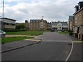
St. Andrews Road, CAMBRIDGE, CB4 1WB
Introduction
This page details the photographs taken nearby to St. Andrews Road, CB4 1WB by members of the Geograph project.
The Geograph project started in 2005 with the aim of publishing, organising and preserving representative images for every square kilometre of Great Britain, Ireland and the Isle of Man.

There are currently over 7.5m images from over14,400 individuals and you can help contribute to the project by visiting https://www.geograph.org.uk
Image Map
Images are licensed for reuse under creativecommons.org/licenses/by-sa/2.0
Notes
- Clicking on the map will re-center to the selected point.
- The higher the marker number, the further away the image location is from the centre of the postcode.
Image Listing (290 Images Found)
Images are licensed for reuse under creativecommons.org/licenses/by-sa/2.0
Image
Details
Distance
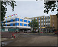
1
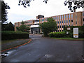
Elizabeth House
Office block, with planning permission sought for a conversion to halls of residence for 261 students.
Image: © Hugh Venables
Taken: 25 Aug 2012
0.01 miles
2
Elizabeth House
In the process of being converted from offices to student accommodation, see Image
Image: © Hugh Venables
Taken: 15 Aug 2014
0.02 miles
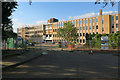
3
Elizabeth House
Being converted from offices to student accommodation.
Image: © Hugh Venables
Taken: 5 Mar 2015
0.02 miles
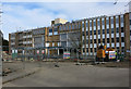
4
Elizabeth House conversion continues
See Image
Image: © Hugh Venables
Taken: 27 Nov 2014
0.02 miles
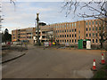
5
Elizabeth House conversion nearing completion
Formerly an office block, now student accommodation. The first summer students are in as landscaping works continue. See Image
Image: © Hugh Venables
Taken: 17 Jul 2015
0.03 miles
6
CATS college - Cambridge
International boarding education for students 14+.
Image: © Fernweh
Taken: 20 Feb 2017
0.03 miles
7
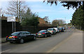
High Street, Chesterton
With a queue for the roundabout as usual.
Image: © Hugh Venables
Taken: 5 Mar 2015
0.05 miles
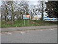
9
New housing
On the site of the old Chesterton Hospital. Chesterton Medical Centre is on the left. The open nature of the site (and the fact that it is not landscaped) makes it look like a further phase of building will come.
Edit Feb 2012: See Image for a more recent view, which does indeed include a new building.
Image: © Hugh Venables
Taken: 1 Sep 2007
0.07 miles
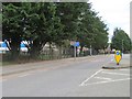
10
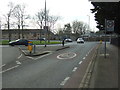
High Street, Chesterton
Looking west towards the roundabout on the A1134.
Image: © JThomas
Taken: 18 Feb 2017
0.07 miles