IMAGES TAKEN NEAR TO
Croftgate, CAMBRIDGE, CB3 9EG
Introduction
This page details the photographs taken nearby to Croftgate, CB3 9EG by members of the Geograph project.
The Geograph project started in 2005 with the aim of publishing, organising and preserving representative images for every square kilometre of Great Britain, Ireland and the Isle of Man.

There are currently over 7.5m images from over14,400 individuals and you can help contribute to the project by visiting https://www.geograph.org.uk
Image Map
Images are licensed for reuse under creativecommons.org/licenses/by-sa/2.0
Notes
- Clicking on the map will re-center to the selected point.
- The higher the marker number, the further away the image location is from the centre of the postcode.
Image Listing (143 Images Found)
Images are licensed for reuse under creativecommons.org/licenses/by-sa/2.0
Image
Details
Distance
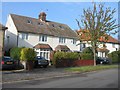
1
A stench pipe at the end of Fulbrooke Road
This well-preserved example was supplied, like many in Cambridge, by Ham, Baker & Co Ltd. It does not appear on the 2013 blog-map which shows the majority of Cambridge stinkpipes (and some which have subsequently disappeared) - https://www.google.com/maps/d/viewer?mid=1tGa-vqWr8XI064h9UKIdCi-HU70&ll=52.20093555963424%2C0.1343196499999877&z=13 . This picture was taken from the entrance to King's & Selwyn Colleges Sports Ground (left).
Image: © John Sutton
Taken: 17 Jul 2020
0.03 miles
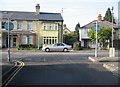
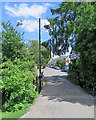
2
Newnham: the end of Fulbrooke Road
Fulbrooke Road ends at the gate to the model engineers' miniature railway tracks, allotments and King's & Selwyn Sports Ground. For another look at the green sewer vent pipe on the right of the picture, see Image
Image: © John Sutton
Taken: 7 Mar 2022
0.03 miles
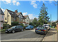
3
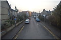
Fulbrooke Road
Mostly late-Victorian and Edwardian houses on the western edge of Cambridge.
Image: © John Sutton
Taken: 12 Jun 2021
0.07 miles
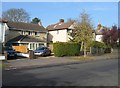
4
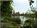
Bolton's Pit
Bolton's Pit on the south side of Barton Road was first quarried for clay for local brickworks, approached from Grantchester Road during late Victorian era and then during 1900s coprolites were extracted for fertilizers and explosives until it was used as a rubbish tip during and after WW1 when it then filled with water from Binn Brook and became naturalised. Many of the houses around were built in the 1920s and 1930s by local Walter Boyton using the typical Cambridge yellowish brick.
Image: © Francis Hookham
Taken: 10 May 2008
0.09 miles
5
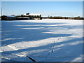
King's & Selwyn Colleges' Sports Ground in the snow
Image: © John Sutton
Taken: 9 Jan 2010
0.10 miles
6
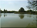
Bolton's Pit
Bolton's Pit on the south side of Barton Road was first quarried for clay for local brickworks, approached from Grantchester Road during late Victorian era and then during 1900s coprolites were extracted for fertilizers and explosives until it was used as a rubbish tip during and after WW1 when it then filled with water from Binn Brook and became naturalised. Many of the houses around were built in the 1920s and 1930s by local Walter Boyton using the typical Cambridge yellowish brick.
Image: © Francis Hookham
Taken: 10 May 2008
0.10 miles