IMAGES TAKEN NEAR TO
Brook End Close, CAMBRIDGE, CB2 9DB
Introduction
This page details the photographs taken nearby to Brook End Close, CB2 9DB by members of the Geograph project.
The Geograph project started in 2005 with the aim of publishing, organising and preserving representative images for every square kilometre of Great Britain, Ireland and the Isle of Man.

There are currently over 7.5m images from over14,400 individuals and you can help contribute to the project by visiting https://www.geograph.org.uk
Image Map
Images are licensed for reuse under creativecommons.org/licenses/by-sa/2.0
Notes
- Clicking on the map will re-center to the selected point.
- The higher the marker number, the further away the image location is from the centre of the postcode.
Image Listing (556 Images Found)
Images are licensed for reuse under creativecommons.org/licenses/by-sa/2.0
Image
Details
Distance
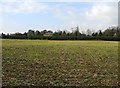
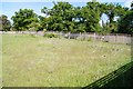
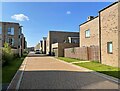
3
Original hedgeline - Clay Farm
The farm has long gone and been covered by hundreds of houses, between different phases the developers have left the original tree and hedge field boundaries.
To the left of this view is a new road known as Willers Lane.
This is the view Image (in the opposite direction) taken 7 years earlier.
Image: © Fernweh
Taken: 11 Aug 2021
0.01 miles
4
Fenced off former Clay Farm field
One of the last fields to remain untouched. Most of the others are now being built upon, this will be once the other phases of construction are completed.
Image: © Fernweh
Taken: 17 May 2015
0.01 miles
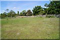
5
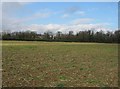
Clay Farm farmland
The trees in the distance mark the course of Long Road.
Image: © Mr Ignavy
Taken: 19 Feb 2009
0.01 miles
6
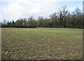
Clay Farm farmland
Long Road lies beyond the tree line.
Image: © Mr Ignavy
Taken: 19 Feb 2009
0.01 miles
7
New & old boundary
To my right lies the original hedge field boundary. Beyond the fence is the rest of the field waiting to be built over as part of the Clay Farm housing development.
Image: © Fernweh
Taken: 17 May 2015
0.02 miles
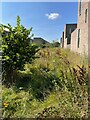
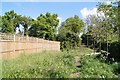
9
Last field surviving - Clay Farm
View over the fence which marks the current limit of the development. I'm fairly sure this will eventually be built over.
Image: © Fernweh
Taken: 17 May 2015
0.02 miles