IMAGES TAKEN NEAR TO
Chapmans Close, CAMBRIDGE, CB25 9GQ
Introduction
This page details the photographs taken nearby to Chapmans Close, CB25 9GQ by members of the Geograph project.
The Geograph project started in 2005 with the aim of publishing, organising and preserving representative images for every square kilometre of Great Britain, Ireland and the Isle of Man.

There are currently over 7.5m images from over14,400 individuals and you can help contribute to the project by visiting https://www.geograph.org.uk
Image Map
Images are licensed for reuse under creativecommons.org/licenses/by-sa/2.0
Notes
- Clicking on the map will re-center to the selected point.
- The higher the marker number, the further away the image location is from the centre of the postcode.
Image Listing (171 Images Found)
Images are licensed for reuse under creativecommons.org/licenses/by-sa/2.0
Image
Details
Distance
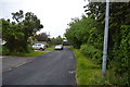
3
Landbeach: Reubens Road
Council-built houses on the western edge of the village, near the parish church.
Image: © John Sutton
Taken: 27 Oct 2019
0.05 miles
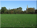
6
Recreation ground at Landbeach
A glimpse of the church in the background, a landmark that can be seen from afar.
Image: © Peter S
Taken: 21 Aug 2020
0.06 miles
10
Landbeach Recreation Ground in late October
Slightly discordant bells were summoning parishioners to the ten o'clock Sunday service at All Saints' Church.
Image: © John Sutton
Taken: 27 Oct 2019
0.07 miles