IMAGES TAKEN NEAR TO
Abbey Lane, CAMBRIDGE, CB25 0NQ
Introduction
This page details the photographs taken nearby to Abbey Lane, CB25 0NQ by members of the Geograph project.
The Geograph project started in 2005 with the aim of publishing, organising and preserving representative images for every square kilometre of Great Britain, Ireland and the Isle of Man.

There are currently over 7.5m images from over14,400 individuals and you can help contribute to the project by visiting https://www.geograph.org.uk
Image Map
Images are licensed for reuse under creativecommons.org/licenses/by-sa/2.0
Notes
- Clicking on the map will re-center to the selected point.
- The higher the marker number, the further away the image location is from the centre of the postcode.
Image Listing (70 Images Found)
Images are licensed for reuse under creativecommons.org/licenses/by-sa/2.0
Image
Details
Distance
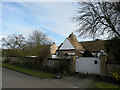
1
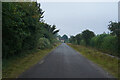
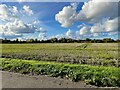
Near Swaffham Bulbeck
On the edge of the village close by an old priory.
Image: © Malcolm Neal
Taken: 9 Sep 2021
0.02 miles
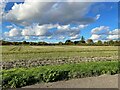
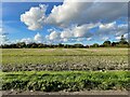
4
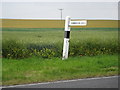
Swaffham Bulbeck: Sign to Commercial End
This fingerpost is on the B1102 showing the road, Abbey Lane, to Commercial End in Swaffham Bulbeck. Beyond is the rolling arable farmland of south Cambridgeshire.
Image: © Nigel Cox
Taken: 6 Jul 2008
0.10 miles
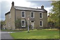
7
96 - 100 Commercial End
Grade II listed. https://britishlistedbuildings.co.uk/101165767-96-98-and-100-commercial-end-swaffham-bulbeck
Image: © N Chadwick
Taken: 27 Oct 2018
0.12 miles
8
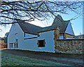
Swaffham Bulbeck: The Malt House, Commercial End
The malt kiln is now part of a house, whose elaborate doorway is dated 1697. The house, largely hidden from the street by a substantial wall, is Grade II listed.
Commercial End flourished from the 17th century onwards, when goods were brought along the Lode from the Cam. River traffic dwindled after the coming of the railway,
Image: © John Sutton
Taken: 21 Jan 2023
0.13 miles
9
The Malt House, Commercial End
Maltings and kiln now converted to dwellings, C18. Mainly clunch but with some brick. Plain tiled roof with a sawtooth eaves cornice. Group II listed, included for group value, LBS Number: 49422. http://www.heritagegateway.org.uk/Gateway/Results_Single.aspx?uid=49422&resourceID=5
Image: © Keith Edkins
Taken: 27 Feb 2009
0.13 miles
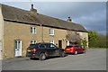
10
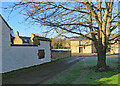
Swaffham Bulbeck: winter sunlight, Commercial End
The Malt House is on the left, with the grand 17th-century Merchant's House beyond it and The Granary straight ahead. These all date from the time before the coming of the railway, when Commercial End was a thriving river port, connected to the River Cam by Swaffham Bulbeck Lode.
Image]
Image]
Image]
Image: © John Sutton
Taken: 21 Jan 2023
0.13 miles