IMAGES TAKEN NEAR TO
Fen Lane, CAMBRIDGE, CB25 0NJ
Introduction
This page details the photographs taken nearby to Fen Lane, CB25 0NJ by members of the Geograph project.
The Geograph project started in 2005 with the aim of publishing, organising and preserving representative images for every square kilometre of Great Britain, Ireland and the Isle of Man.

There are currently over 7.5m images from over14,400 individuals and you can help contribute to the project by visiting https://www.geograph.org.uk
Image Map
Images are licensed for reuse under creativecommons.org/licenses/by-sa/2.0
Notes
- Clicking on the map will re-center to the selected point.
- The higher the marker number, the further away the image location is from the centre of the postcode.
Image Listing (47 Images Found)
Images are licensed for reuse under creativecommons.org/licenses/by-sa/2.0
Image
Details
Distance
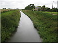
2
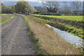
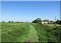
Swaffham Bulbeck Lode
The farm is Cowbridge Farm seen from Cow Bridge on Swaffham Bulbeck Lode. Lode is a fenland term for an open drain.
Image: © Stephen McKay
Taken: 17 Sep 2006
0.00 miles
4
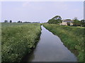
Swaffham Bulbeck Lode from Cow Bridge
Swaffham Bulbeck Lode was once a navigable waterway and Commercial End a river port. The coming of the railway in the 1880s put a stop to that.
Image: © John Sutton
Taken: 25 May 2020
0.01 miles
5
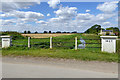
Swaffham Bulbeck Lode
Viewed from Cow Bridge, Commercial End. Speyside Farm is visible on the right.
Image: © Ajay Tegala
Taken: 29 May 2003
0.03 miles
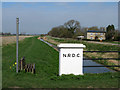
6
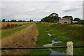
Swaffham Bulbeck Lode from Cow Bridge
The lode was navigated to Commercial End until about the 1900s, when the bridge here must have been more suitable than this 1927 replacement, which has a rather limited cross-section under it. N.R.D.C. stands for Newmarket Rural District Council.
Image: © Robin Webster
Taken: 6 Aug 2016
0.03 miles
7
Swaffham Bulbeck Lode, from Cow Bridge
Although the map marks a lock at the entrance to the lode from the River Cam, it can be seen at Image that the channel is now used only for drainage, not navigation, explaining the state of the channel at this end.
On the right, Cowbridge Farm.
Image: © Christopher Hilton
Taken: 2 Aug 2021
0.04 miles
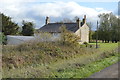
8
Cow Bridge and Swaffham Bulbeck Lode
The bridge was built by Newmarket Rural District Council in 1927. The next bridge over the Lode, in the distance, once carried the Cambridge to Mildenhall railway. Paths either side of the water lead to where the Lode meets the Cam, at Swaffham Lock.
Image: © John Sutton
Taken: 23 Mar 2011
0.05 miles
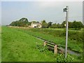
9
Swaffham Bulbeck Lode
The lode drains into the River Cam and is viewed here from Image At this point the lode is in Swaffham Bulbeck Civil Parish but a short way down the boundary with Lode Civil Parish comes in from the left and the boundary then runs down the centre of the lode into the distance. This photo was taken from the same point as Ajay's Image but over five years later. About the only noticeable change is that the vegetation along the footpath on the left side of the lode has been comprehensively mown back, while five years earlier it appeared to be something of a jungle.
Image: © Nigel Cox
Taken: 6 Jul 2008
0.05 miles