IMAGES TAKEN NEAR TO
Downing Court, CAMBRIDGE, CB25 0LP
Introduction
This page details the photographs taken nearby to Downing Court, CB25 0LP by members of the Geograph project.
The Geograph project started in 2005 with the aim of publishing, organising and preserving representative images for every square kilometre of Great Britain, Ireland and the Isle of Man.

There are currently over 7.5m images from over14,400 individuals and you can help contribute to the project by visiting https://www.geograph.org.uk
Image Map
Images are licensed for reuse under creativecommons.org/licenses/by-sa/2.0
Notes
- Clicking on the map will re-center to the selected point.
- The higher the marker number, the further away the image location is from the centre of the postcode.
Image Listing (132 Images Found)
Images are licensed for reuse under creativecommons.org/licenses/by-sa/2.0
Image
Details
Distance
1
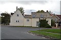
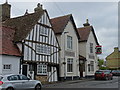
48, High St
Grade II listed. https://britishlistedbuildings.co.uk/101165849-48-high-street-swaffham-bulbeck
Image: © N Chadwick
Taken: 27 Oct 2018
0.04 miles
2
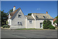
Swaffham Bulbeck: on High Street
A Grade II listed timber-framed house on the corner. The 19th-century pantiled wing is built of clunch.
Image: © John Sutton
Taken: 25 May 2020
0.04 miles
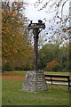
6
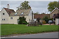
Swaffham Bulbeck War Memorial
Grade II listed. https://britishlistedbuildings.co.uk/101424185-swaffham-bulbeck-war-memorial-swaffham-bulbeck
Image: © N Chadwick
Taken: 27 Oct 2018
0.06 miles