IMAGES TAKEN NEAR TO
High Street, CAMBRIDGE, CB25 0HB
Introduction
This page details the photographs taken nearby to High Street, CB25 0HB by members of the Geograph project.
The Geograph project started in 2005 with the aim of publishing, organising and preserving representative images for every square kilometre of Great Britain, Ireland and the Isle of Man.

There are currently over 7.5m images from over14,400 individuals and you can help contribute to the project by visiting https://www.geograph.org.uk
Image Map
Images are licensed for reuse under creativecommons.org/licenses/by-sa/2.0
Notes
- Clicking on the map will re-center to the selected point.
- The higher the marker number, the further away the image location is from the centre of the postcode.
Image Listing (113 Images Found)
Images are licensed for reuse under creativecommons.org/licenses/by-sa/2.0
Image
Details
Distance
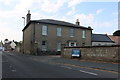
1
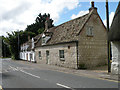
Cottages in High Street, Burwell
The white building, not divided into 2 houses, dates from the 17th century although the rendering is much later. The nearer building is late C18 or early C19. Both Grade II listed for Group Value.
Image: © Keith Edkins
Taken: 10 Aug 2017
0.02 miles
2
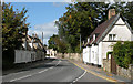
Burwell, High Street 2009
Imitation of "Burwell, High Street c1955" http://www.francisfrith.com/burwell,cambridgeshire/photos/high-street-c1955_b728031/ in the Frith Collection
Image: © Keith Edkins
Taken: 10 Sep 2009
0.03 miles
3
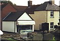
Lane's Bakery, Burwell, Cambridgeshire
Ten years on, this cute little bakery is still baking bread and cakes for the village of Burwell.
Image: © nick macneill
Taken: 13 Oct 2000
0.04 miles
4
Isaacsons
Probably the oldest surviving secular building in the village, provisionally dated c.1340. Opinions on its history vary, one possibility is that it was the manor house of St Omers manor; another is that it was a hostel for the Knights of St John. It is thought that originally a further range of buildings including a gatehouse extended to the northeast. The house was owned for many years by the Isaacson family, prominent local farmers, who also gave their name to the adjoining road.
Image: © Tony Lewis
Taken: 11 Feb 2009
0.05 miles
5
Burwell: Mandeville, The Maltings and St Mary's
Mandeville is the street name. The Grade II listed maltings on the left date from the late 18th century. The walls are clunch, the chalk which is the only building stone found in this part of the world. For a look at the whole of the parish church, see Image
Image: © John Sutton
Taken: 15 Sep 2020
0.05 miles
6
Looking south-southeast down the High Street
Image: © Basher Eyre
Taken: 2 Oct 2023
0.05 miles
7
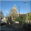
Burwell: the corner of Church Lane
A view towards St Mary's Church (in Image) on a December day of intense sunlight and deep shadow.
Image: © John Sutton
Taken: 6 Dec 2014
0.05 miles
8
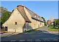
Burwell: The Maltings
The Grade II listed maltings dates from the late 18th century. Its kiln is tiled and the rest of the granary thatched, with pantiled dormers. The walls are clunch, the chalk which is the only building stone found in this part of the world.
Image: © John Sutton
Taken: 15 Sep 2020
0.05 miles
10
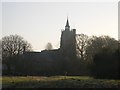
St Mary's Church
With part of the castle earthworks in the foreground.
Image: © Tony Lewis
Taken: 17 Dec 2007
0.06 miles