IMAGES TAKEN NEAR TO
Burling Way, CAMBRIDGE, CB25 0FJ
Introduction
This page details the photographs taken nearby to Burling Way, CB25 0FJ by members of the Geograph project.
The Geograph project started in 2005 with the aim of publishing, organising and preserving representative images for every square kilometre of Great Britain, Ireland and the Isle of Man.

There are currently over 7.5m images from over14,400 individuals and you can help contribute to the project by visiting https://www.geograph.org.uk
Image Map
Images are licensed for reuse under creativecommons.org/licenses/by-sa/2.0
Notes
- Clicking on the map will re-center to the selected point.
- The higher the marker number, the further away the image location is from the centre of the postcode.
Image Listing (39 Images Found)
Images are licensed for reuse under creativecommons.org/licenses/by-sa/2.0
Image
Details
Distance
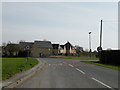
1
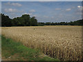
Burling Way, Burwell
Recent expansion of the village.
Image: © Hugh Venables
Taken: 26 Jun 2021
0.03 miles
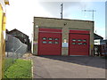
4
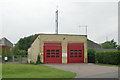
Burwell fire station
Burwell fire station, Scotred Lane, Burwell, Cambridgeshire
Image: © Kevin Hale
Taken: 2 Jun 2008
0.06 miles
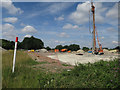
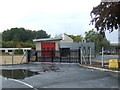
5
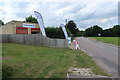
Covid testing site
In the old fire station on the edge of Burwell.
Image: © Hugh Venables
Taken: 26 Jun 2021
0.06 miles
6
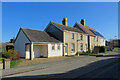
Burwell: clunch walls on Reach Road
The walls of these Victorian cottages (but not I think their rendered extensions) are clunch, the local building stone, a type of chalk. Clunch is soft and weathers quickly, so the quoins and window reveals are brick.
Image: © John Sutton
Taken: 25 Feb 2022
0.06 miles
7
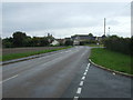
National Cycle Route 51
Heading south east on Reach Road.
Image: © JThomas
Taken: 15 Oct 2015
0.07 miles
8
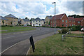
Entering Burwell
Modern housing in Railway Close
Image: © Keith Edkins
Taken: 16 Mar 2009
0.08 miles
9
Burwell fire station
Replaced an older station in November 2014 - Image
Image: © JThomas
Taken: 15 Oct 2015
0.08 miles