IMAGES TAKEN NEAR TO
Ash Grove, CAMBRIDGE, CB25 0DR
Introduction
This page details the photographs taken nearby to Ash Grove, CB25 0DR by members of the Geograph project.
The Geograph project started in 2005 with the aim of publishing, organising and preserving representative images for every square kilometre of Great Britain, Ireland and the Isle of Man.

There are currently over 7.5m images from over14,400 individuals and you can help contribute to the project by visiting https://www.geograph.org.uk
Image Map
Images are licensed for reuse under creativecommons.org/licenses/by-sa/2.0
Notes
- Clicking on the map will re-center to the selected point.
- The higher the marker number, the further away the image location is from the centre of the postcode.
Image Listing (32 Images Found)
Images are licensed for reuse under creativecommons.org/licenses/by-sa/2.0
Image
Details
Distance
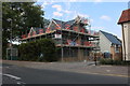
1
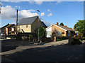
New house, Burwell
Replacing a bungalow.
Image: © Hugh Venables
Taken: 27 Aug 2015
0.09 miles
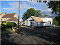

5
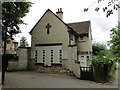
Burwell: The Jubilee Reading Room
The Jubilee Reading Room was opened in 1889 so I guess that the occasion being celebrated was the Golden Jubilee of Queen Victoria's reign in 1887. One of the main purposes was to improve farmers' technical knowledge. It is at 99 The Causeway and is now the office of Burwell Parish Council.
Image: © Nigel Cox
Taken: 6 Jul 2008
0.12 miles
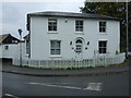
6
Burwell War Memorial
The War Memorial at Burwell is at what is now number 19, The Causeway, Burwell Originally the house was built as a home for the District Nurse.
It is a most unusual situation for a War Memorial. Another, slightly more conventional, can be seen in the church http://www.geograph.org.uk/photo/5461096
Image: © Adrian S Pye
Taken: 13 Jul 2017
0.13 miles
7
New houses on High Street Burwell
This was a pub car park till recently.
Image: © David Howard
Taken: 9 Aug 2020
0.13 miles
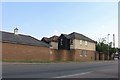
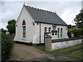
10
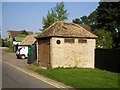
The Village Lock Up
Built c.1830, used until c.1890 for overnight detention of local offenders, later used for storage of the village fire engine.
Image: © Tony Lewis
Taken: 29 Aug 2007
0.14 miles