IMAGES TAKEN NEAR TO
Grantchester Rise, CAMBRIDGE, CB25 0BE
Introduction
This page details the photographs taken nearby to Grantchester Rise, CB25 0BE by members of the Geograph project.
The Geograph project started in 2005 with the aim of publishing, organising and preserving representative images for every square kilometre of Great Britain, Ireland and the Isle of Man.

There are currently over 7.5m images from over14,400 individuals and you can help contribute to the project by visiting https://www.geograph.org.uk
Image Map
Images are licensed for reuse under creativecommons.org/licenses/by-sa/2.0
Notes
- Clicking on the map will re-center to the selected point.
- The higher the marker number, the further away the image location is from the centre of the postcode.
Image Listing (30 Images Found)
Images are licensed for reuse under creativecommons.org/licenses/by-sa/2.0
Image
Details
Distance
1
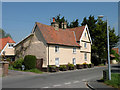
Adventurers, North Street
C16. Timber-framed and clunch, plastered, on brick plinth; red pantiled roof. Note the nice touch: the three casement windows in the gable facade of the cross wing get smaller as you look upwards. Grade II listed, LBS Number: 48978. http://www.heritagegateway.org.uk/Gateway/Results_Single.aspx?uid=48978&resourceID=5
Image: © Keith Edkins
Taken: 1 May 2009
0.07 miles
2
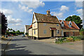
Burwell: on North Street
The Grade II listed pantiled house is timber-framed and dates from the 18th century.
Image: © John Sutton
Taken: 4 Aug 2022
0.07 miles
4
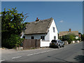
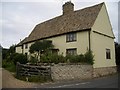
Chestnut Cottage, North Street
Late C16 or early C17. Timber-frame and clunch
plastered with painted brick casing. Thatch roof. Grade II listed, LBS Number: 48976. http://www.heritagegateway.org.uk/Gateway/Results_Single.aspx?uid=48976&resourceID=5
Image: © Keith Edkins
Taken: 1 May 2009
0.09 miles
5
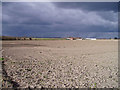
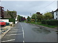
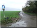
Ridge of high ground near Burwell
'High' is very much a relative term here in the Fens - we are only about 10 metres above sea level, but the contrast is still very apparent between this chalky ridge and the surrounding flat fenland. The village of Burwell is built on the same ridge, which extends northwards out of the more undulating country around Newmarket. Before the Fens were drained this would have been one of the last outposts of solid ground before the peat bogs.
Image: © David Gruar
Taken: 26 Feb 2006
0.10 miles
6
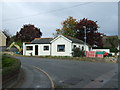
Bungalow on North Street
At the junction with Dyson's Drove.
Image: © JThomas
Taken: 15 Oct 2015
0.11 miles
7
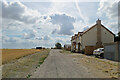
Burwell: Balk Farm on Howlem Balk
Howlem Balk runs from the edge of The Fens at the north end of Burwell (behind the camera) up the first very gentle undulations of the chalk hills around Newmarket.
Image: © John Sutton
Taken: 4 Aug 2022
0.11 miles
8
121, North Street
This house is typical of the older properties in North Street, built end-on to the road, on a long narrow plot with river frontage including a hythe or barge landing, and storage buildings.
Image: © Tony Lewis
Taken: 5 Sep 2007
0.11 miles
9
Dead End
Road leading to Balk Farm at Burwell, Cambridgeshire.
Image: © Keith Evans
Taken: 7 Feb 2017
0.14 miles
10
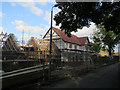
House build. Burwell
On Dyson's Drove.
Image: © Hugh Venables
Taken: 27 Aug 2015
0.15 miles