IMAGES TAKEN NEAR TO
Anchor Lane, CAMBRIDGE, CB25 0BD
Introduction
This page details the photographs taken nearby to Anchor Lane, CB25 0BD by members of the Geograph project.
The Geograph project started in 2005 with the aim of publishing, organising and preserving representative images for every square kilometre of Great Britain, Ireland and the Isle of Man.

There are currently over 7.5m images from over14,400 individuals and you can help contribute to the project by visiting https://www.geograph.org.uk
Image Map
Images are licensed for reuse under creativecommons.org/licenses/by-sa/2.0
Notes
- Clicking on the map will re-center to the selected point.
- The higher the marker number, the further away the image location is from the centre of the postcode.
Image Listing (67 Images Found)
Images are licensed for reuse under creativecommons.org/licenses/by-sa/2.0
Image
Details
Distance
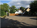
2

Land with planning
Planning for two new houses, with a recently built house behind.
Image: © Hugh Venables
Taken: 27 Aug 2015
0.02 miles
3
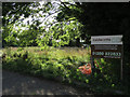
Land with planning for sale
By Anchor Lane.
Image: © Hugh Venables
Taken: 27 Aug 2015
0.02 miles
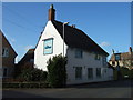
5
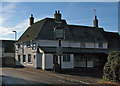
Burwell: The Anchor
On the corner of North Street and Anchor Lane. The sun was still low in the sky at midday on a fine Saturday in December, so north-facing roof slopes stayed frosted.
Image: © John Sutton
Taken: 6 Dec 2014
0.04 miles
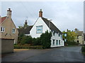
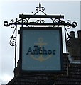
8
The Anchor in Burwell, Cambridgeshire
Image: © Richard Humphrey
Taken: 26 Feb 2014
0.04 miles