IMAGES TAKEN NEAR TO
North Street, CAMBRIDGE, CB25 0BB
Introduction
This page details the photographs taken nearby to North Street, CB25 0BB by members of the Geograph project.
The Geograph project started in 2005 with the aim of publishing, organising and preserving representative images for every square kilometre of Great Britain, Ireland and the Isle of Man.

There are currently over 7.5m images from over14,400 individuals and you can help contribute to the project by visiting https://www.geograph.org.uk
Image Map
Images are licensed for reuse under creativecommons.org/licenses/by-sa/2.0
Notes
- Clicking on the map will re-center to the selected point.
- The higher the marker number, the further away the image location is from the centre of the postcode.
Image Listing (54 Images Found)
Images are licensed for reuse under creativecommons.org/licenses/by-sa/2.0
Image
Details
Distance
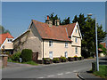
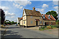
1
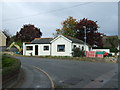
Bungalow on North Street
At the junction with Dyson's Drove.
Image: © JThomas
Taken: 15 Oct 2015
0.01 miles
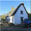
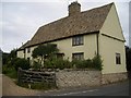
2
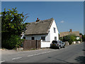
Chestnut Cottage, North Street
Late C16 or early C17. Timber-frame and clunch
plastered with painted brick casing. Thatch roof. Grade II listed, LBS Number: 48976. http://www.heritagegateway.org.uk/Gateway/Results_Single.aspx?uid=48976&resourceID=5
Image: © Keith Edkins
Taken: 1 May 2009
0.03 miles
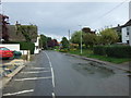
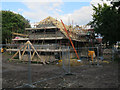
4
House build. Burwell
On Dyson's Drove.
Image: © Hugh Venables
Taken: 27 Aug 2015
0.06 miles
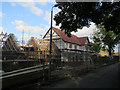
5
Adventurers, North Street
C16. Timber-framed and clunch, plastered, on brick plinth; red pantiled roof. Note the nice touch: the three casement windows in the gable facade of the cross wing get smaller as you look upwards. Grade II listed, LBS Number: 48978. http://www.heritagegateway.org.uk/Gateway/Results_Single.aspx?uid=48978&resourceID=5
Image: © Keith Edkins
Taken: 1 May 2009
0.07 miles
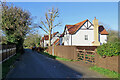
6
New houses, Dyson's Drove
There were several houses recently built or under construction in Burwell.
Image: © Hugh Venables
Taken: 27 Aug 2015
0.07 miles
7
Burwell: on North Street
The Grade II listing begins "Originally late C16 or early C17 with rooms beyond stack to west rebuilt possibly in C18 or early C19. Timber-frame and clunch plastered, with thatched roofs". This house is typical of those in this part of the village: "On North Street, in contrast to the often wide closes around dwellings in High Town, the older houses, most continuous on the west side, stand end-on at the street end of long narrow crofts, sometimes with outbuildings for storage further back. Those crofts run down to private landing places on the Weirs, which there bend east to run eventually only 150 metres west of the street. At the south end, further from the water, some of North Street's houses have individual channels cut to run east from the Weirs" (British History Online). Image] shows the other end of one of these narrow plots.
Image: © John Sutton
Taken: 27 Dec 2020
0.07 miles
8
Burwell: Dyson's Drove
Dyson's Drove soon becomes Factory Road, leading out to remote fenland.
Image: © John Sutton
Taken: 27 Dec 2020
0.08 miles
9
Burwell: on North Street
The Grade II listed pantiled house is timber-framed and dates from the 18th century.
Image: © John Sutton
Taken: 4 Aug 2022
0.08 miles
10
121, North Street
This house is typical of the older properties in North Street, built end-on to the road, on a long narrow plot with river frontage including a hythe or barge landing, and storage buildings.
Image: © Tony Lewis
Taken: 5 Sep 2007
0.08 miles