
IMAGES TAKEN NEAR TO
Swaffham Road, CAMBRIDGE, CB25 0AW
Introduction
This page details the photographs taken nearby to Swaffham Road, CB25 0AW by members of the Geograph project.
The Geograph project started in 2005 with the aim of publishing, organising and preserving representative images for every square kilometre of Great Britain, Ireland and the Isle of Man.

There are currently over 7.5m images from over14,400 individuals and you can help contribute to the project by visiting https://www.geograph.org.uk
Image Map
Images are licensed for reuse under creativecommons.org/licenses/by-sa/2.0
Notes
- Clicking on the map will re-center to the selected point.
- The higher the marker number, the further away the image location is from the centre of the postcode.
Image Listing (15 Images Found)
Images are licensed for reuse under creativecommons.org/licenses/by-sa/2.0
Image
Details
Distance


5
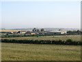
Ditch Farm on a September morning
A view from the Devil's Dyke, taken just before nine o'clock on a September morning. Overnight mist had largely cleared and the rest of the day was cloudless and hot. Burwell church tower, just over a mile away, shows on the skyline above the redbrick farm outbuilding.
Image: © John Sutton
Taken: 15 Sep 2020
0.04 miles
6

Devil's Ditch, Burwell, Cambridgeshire
View of the Devil's Ditch looking south-east. Many wildflowers grow along the ditch, seen in better detail in this photo: Image
Image: © ethics girl
Taken: 14 Jul 2007
0.16 miles


9
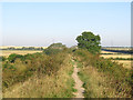
On The Devil's Dyke near Ditch Farm
At 7½ miles (12km) long The Devil's Dyke is the longest and largest of Cambridgeshire's Anglo-Saxon defensive ramparts, which date from the 6th and 7th centuries. It stretches from Wood Ditton in the chalk hills south of Newmarket to Reach on the edge of the then-undrained Fens (ahead). The ditch on the south side and the rampart vary in depth and height: here the ditch is deep and the rampart high.
Image: © John Sutton
Taken: 15 Sep 2020
0.17 miles
