IMAGES TAKEN NEAR TO
Manor Park, CAMBRIDGE, CB24 9JT
Introduction
This page details the photographs taken nearby to Manor Park, CB24 9JT by members of the Geograph project.
The Geograph project started in 2005 with the aim of publishing, organising and preserving representative images for every square kilometre of Great Britain, Ireland and the Isle of Man.

There are currently over 7.5m images from over14,400 individuals and you can help contribute to the project by visiting https://www.geograph.org.uk
Image Map
Images are licensed for reuse under creativecommons.org/licenses/by-sa/2.0
Notes
- Clicking on the map will re-center to the selected point.
- The higher the marker number, the further away the image location is from the centre of the postcode.
Image Listing (54 Images Found)
Images are licensed for reuse under creativecommons.org/licenses/by-sa/2.0
Image
Details
Distance
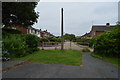
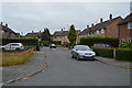
2
St Audrey's Close
Foot and cycle link through to Manor Park.
Image: © Hugh Venables
Taken: 25 Oct 2015
0.04 miles

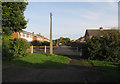
8
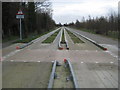
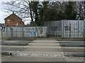
Histon: The Cambridgeshire Guided Busway
With buses conspicuous by their absence, and Cambridgeshire County Council and the main construction contractor BAM Nuttall locked in a contractual dispute, the new busway remains unopened, with currently no date set for an opening. This is the view from the public footpath crossing from St Audrey's Close to Histon Wood and thence to Girton along the route of the former Cambridge and St Ives railway line, which the new busway follows for a substantial section of its route. The railway closed to passenger traffic in 1970, and to freight in the 1990s.
To the outsider, who has in part funded the scheme though taxation since £92.5 million of the cost was allegedly provided by central government, the sign on the left just about sums up the whole sorry farrago. Why is there a warning sign advising of the crossing located immediately after a bus would have passed it...? If the sign is meant to warn pedestrians of the crossing why is it not aligned in their direction of travel?
Image: © Nigel Cox
Taken: 5 Feb 2011
0.11 miles
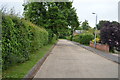
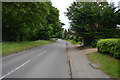
9
Bridleway crosses Guided busway & National Cycle Route 51
Image: © N Chadwick
Taken: 27 Oct 2016
0.11 miles
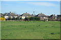
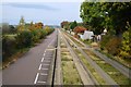
10
Pedestrian crossing over the Cambridge Guided Busway, Histon
Image: © JThomas
Taken: 18 Feb 2017
0.11 miles