IMAGES TAKEN NEAR TO
Norman Way Industrial Estate, Norman Way, CAMBRIDGE, CB24 5WE
Introduction
This page details the photographs taken nearby to Norman Way Industrial Estate, Norman Way, CB24 5WE by members of the Geograph project.
The Geograph project started in 2005 with the aim of publishing, organising and preserving representative images for every square kilometre of Great Britain, Ireland and the Isle of Man.

There are currently over 7.5m images from over14,400 individuals and you can help contribute to the project by visiting https://www.geograph.org.uk
Image Map
Images are licensed for reuse under creativecommons.org/licenses/by-sa/2.0
Notes
- Clicking on the map will re-center to the selected point.
- The higher the marker number, the further away the image location is from the centre of the postcode.
Image Listing (24 Images Found)
Images are licensed for reuse under creativecommons.org/licenses/by-sa/2.0
Image
Details
Distance
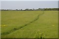
2
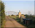
Hill Farm entrance track
Off Longstanton Road just south of Over.
Image: © Hugh Venables
Taken: 6 Aug 2014
0.12 miles
3
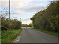
Longstanton Road
Heading away from Over.
Image: © Robin Webster
Taken: 5 Nov 2017
0.13 miles
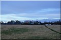
6
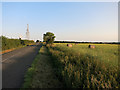
Longstanton Road
Looking towards the windmill and communication tower.
Image: © Hugh Venables
Taken: 6 Aug 2014
0.18 miles
7

?At Over They Fling Oaths at One?
These days oaths are only likely to be thrown at you for fishing in the local pond shown here. There is a prominently displayed by-law, “Fishing in this pond is only permitted for Over residents under the age of eleven years”. For an explanation of the title see http://www.poetsgraves.co.uk/Classic%20Poems/Brooke/grantchester.htm
Image: © Glyn Baker
Taken: 31 Aug 2005
0.20 miles
8
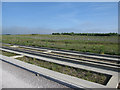
New woodland by the Guided Busway
Habitat mitigation for the trees removed from Over Cutting Image to make room for the guided busway.
Image: © Hugh Venables
Taken: 22 May 2010
0.20 miles
9
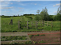
Bridleway from Busway
New path to link to Over, but it makes more sense to drop down by the bridge, Image
Image: © Hugh Venables
Taken: 3 Jun 2017
0.20 miles