IMAGES TAKEN NEAR TO
Saxon Way, CAMBRIDGE, CB24 5UR
Introduction
This page details the photographs taken nearby to Saxon Way, CB24 5UR by members of the Geograph project.
The Geograph project started in 2005 with the aim of publishing, organising and preserving representative images for every square kilometre of Great Britain, Ireland and the Isle of Man.

There are currently over 7.5m images from over14,400 individuals and you can help contribute to the project by visiting https://www.geograph.org.uk
Image Map
Images are licensed for reuse under creativecommons.org/licenses/by-sa/2.0
Notes
- Clicking on the map will re-center to the selected point.
- The higher the marker number, the further away the image location is from the centre of the postcode.
Image Listing (187 Images Found)
Images are licensed for reuse under creativecommons.org/licenses/by-sa/2.0
Image
Details
Distance
1
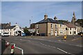
Willingham: Saxon Way
One of the newer roads in the village, approached from High Street. The spire of the parish church shows above the trees to the left of centre.
Image: © John Sutton
Taken: 16 Mar 2020
0.03 miles
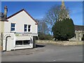
2
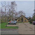
Willingham Medical Practice and Dispensary
Off Long Lane in the centre of the village
Image: © John Sutton
Taken: 16 Mar 2020
0.06 miles
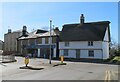
3
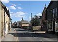
Willingham High Street
"The village of Willingham is long and not attractive," wrote an unimpressed Nikolaus Pevsner in 1954. The parish church (whose spire shows over the rooftops) merited two pages, however.
Image: © John Sutton
Taken: 2 Apr 2013
0.07 miles
4
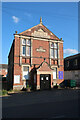
Willingham Public Hall
Given to the parish in 1896 but now only used by Beavers, Cubs and Scouts.
Image: © Hugh Venables
Taken: 3 Jun 2023
0.08 miles
5
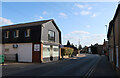
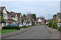
High Street, Willingham
The B1050 is quite a main road for a B road as it is one of the few ways to cross the Great Ouse to the north.
Image: © Hugh Venables
Taken: 3 Jun 2023
0.09 miles
6
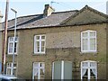
Ghost sign on Church Street
I can only make out the last line - Fine Ales & Stouts.
Image: © Fernweh
Taken: 5 Apr 2018
0.09 miles
7
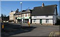
Willingham: at the corner of Church Street
Cabread House, to the right of the Co-op, dates from around 1600 and is Grade II listed - see http://www.britishlistedbuildings.co.uk/en-50900-2-high-street-willingham-cambridgeshire .
Image: © John Sutton
Taken: 27 Feb 2015
0.09 miles
9
Boswell - Church Street
At the time this photo was submitted to the site these premises were known as North's Bakery.
Image: © Fernweh
Taken: 5 Apr 2018
0.09 miles