IMAGES TAKEN NEAR TO
Mustills Lane, CAMBRIDGE, CB24 5PW
Introduction
This page details the photographs taken nearby to Mustills Lane, CB24 5PW by members of the Geograph project.
The Geograph project started in 2005 with the aim of publishing, organising and preserving representative images for every square kilometre of Great Britain, Ireland and the Isle of Man.

There are currently over 7.5m images from over14,400 individuals and you can help contribute to the project by visiting https://www.geograph.org.uk
Image Map
Images are licensed for reuse under creativecommons.org/licenses/by-sa/2.0
Notes
- Clicking on the map will re-center to the selected point.
- The higher the marker number, the further away the image location is from the centre of the postcode.
Image Listing (19 Images Found)
Images are licensed for reuse under creativecommons.org/licenses/by-sa/2.0
Image
Details
Distance
2
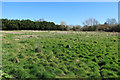
Field on the edge of Over
Acquired for development.
Image: © Hugh Venables
Taken: 21 Mar 2020
0.09 miles
3
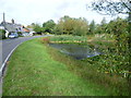
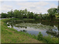
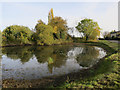
Sandpit Pond, Over
Sandpit Pond suggests by its name that it is artificial and was dug for sand at some time in the past. It is alongside Longstanton Road as the village is entered from Longstanton and Over Windmill.
Image: © Marathon
Taken: 22 Sep 2011
0.09 miles
4
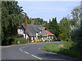
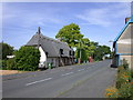
Sandpit and Angel Cottages, Over
Late C17 or C18 and C19. Timber framed, rendered, and part cased in gault brick in C19. Reed thatch roof with axial ridge stack. Grade II listed, LBS Number: 50856. http://www.heritagegateway.org.uk/Gateway/Results_Single.aspx?resourceID=5&uid=50856 - lists it as one property called "Glywood".
Image: © Keith Edkins
Taken: 30 Jul 2008
0.10 miles
6
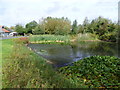
Sandpit Pond, Over
Sandpit Pond suggests by its name that it is artificial and was dug for sand at some time in the past. It is alongside Longstanton Road as the village is entered from Longstanton and Over Windmill.
Image: © Marathon
Taken: 22 Sep 2011
0.12 miles
8
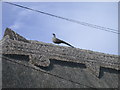
West Street, Over
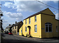
Possibly of C17 origin but mainly C18. One bay to left hand may be timber framed, rendered but the rest is red and yellow gault brick "with corrugated iron roof originally thatched" - thus says the listed buildings register from 1984 but it seems to be all thatched now. LBS Number: 50865. http://www.heritagegateway.org.uk/Gateway/Results_Single.aspx?resourceID=5&uid=50865
See pheasant detail: Image
Image: © Keith Edkins
Taken: 30 Jul 2008
0.12 miles
10
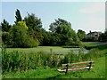
?At Over They Fling Oaths at One?
These days oaths are only likely to be thrown at you for fishing in the local pond shown here. There is a prominently displayed by-law, “Fishing in this pond is only permitted for Over residents under the age of eleven years”. For an explanation of the title see http://www.poetsgraves.co.uk/Classic%20Poems/Brooke/grantchester.htm
Image: © Glyn Baker
Taken: 31 Aug 2005
0.14 miles