IMAGES TAKEN NEAR TO
Lowburyholme Road, CAMBRIDGE, CB24 5NP
Introduction
This page details the photographs taken nearby to Lowburyholme Road, CB24 5NP by members of the Geograph project.
The Geograph project started in 2005 with the aim of publishing, organising and preserving representative images for every square kilometre of Great Britain, Ireland and the Isle of Man.

There are currently over 7.5m images from over14,400 individuals and you can help contribute to the project by visiting https://www.geograph.org.uk
Image Map
Images are licensed for reuse under creativecommons.org/licenses/by-sa/2.0
Notes
- Clicking on the map will re-center to the selected point.
- The higher the marker number, the further away the image location is from the centre of the postcode.
Image Listing (114 Images Found)
Images are licensed for reuse under creativecommons.org/licenses/by-sa/2.0
Image
Details
Distance
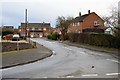
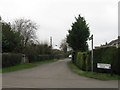
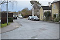
3
Building plot by Station Road
Infill development in Over.
Image: © Hugh Venables
Taken: 17 Sep 2022
0.04 miles
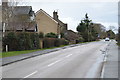
6
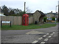
Telephone box and bus shelter on Station Road, Over
Image: © JThomas
Taken: 18 Feb 2017
0.06 miles
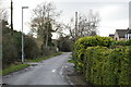
7
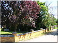
The former end of Lowburyholme Rd
Copper Beech tree in Mel's yard.
Image: © Michael Chamberlain
Taken: 15 Jul 2006
0.06 miles
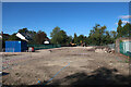
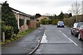
9
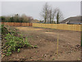
Cleared plot, Over
On the edge of the village by Station Road.
Image: © Hugh Venables
Taken: 3 Mar 2012
0.08 miles