IMAGES TAKEN NEAR TO
Meadow Lane, CAMBRIDGE, CB24 5NF
Introduction
This page details the photographs taken nearby to Meadow Lane, CB24 5NF by members of the Geograph project.
The Geograph project started in 2005 with the aim of publishing, organising and preserving representative images for every square kilometre of Great Britain, Ireland and the Isle of Man.

There are currently over 7.5m images from over14,400 individuals and you can help contribute to the project by visiting https://www.geograph.org.uk
Image Map
Images are licensed for reuse under creativecommons.org/licenses/by-sa/2.0
Notes
- Clicking on the map will re-center to the selected point.
- The higher the marker number, the further away the image location is from the centre of the postcode.
Image Listing (69 Images Found)
Images are licensed for reuse under creativecommons.org/licenses/by-sa/2.0
Image
Details
Distance
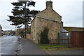
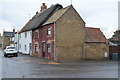
2
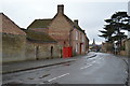
The Old Black Horse, Over
I take this to mean the former Black Horse - old directories show a pub of that name in the village.
Image: © Keith Edkins
Taken: 30 Jul 2008
0.08 miles
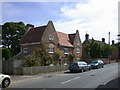
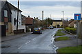
3
High Street, Over
Looking west towards the church.
Image: © Robin Webster
Taken: 5 Nov 2017
0.08 miles
4
Thatched pigs in High Street, Over
It is a custom when thatching to sometimes add an animal or bird on the apex of the roof, possibly as a trademark. This wonderful example of three pigs following each other is on this house in High Street in Over. For another example further north in Cambridgeshire see http://www.geograph.org.uk/photo/2445720 and for one in Kent see https://www.geograph.org.uk/photo/6607579
Image: © Marathon
Taken: 22 Sep 2011
0.08 miles
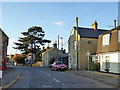
6
Fen End 2012, Over
Recreation of the image "Fen Lane c1965, Over" in the Frith Collection http://www.francisfrith.com/over,cambridgeshire/photos/fen-lane-c1965_O114015/ (Either Frith's boys got the street name wrong or it has changed in the intervening 50 years)
To see the two images together follow this http://www.geograph.org.uk/stuff/frith.php?id=2953006
Image: © Keith Edkins
Taken: 19 May 2012
0.08 miles
7
4, High St
Grade II listed. https://www.britishlistedbuildings.co.uk/101127306-4-high-street-over#.WuB54H8kp1s
Image: © N Chadwick
Taken: 11 Feb 2018
0.09 miles
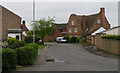
8
17, High St
Grade II listed. https://www.britishlistedbuildings.co.uk/101164476-17-high-street-over
Image: © N Chadwick
Taken: 11 Feb 2018
0.09 miles
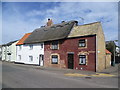
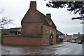
9
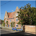
Over: The Old Black Horse
This house of c 1660 has a look of the Low Countries about it and the listing suggests it may be associated with Dutch prisoners of war engaged in the construction of the New Bedford River who remained at Over after the Treaty of Westminster, which ended the First Dutch War in 1654 - see http://www.britishlistedbuildings.co.uk/en-50845-22-high-street-over-cambridgeshire .
Image: © John Sutton
Taken: 10 Oct 2014
0.09 miles
10
13, High St
Grade II listed. https://www.britishlistedbuildings.co.uk/101127306-4-high-street-over#.WuB54H8kp1s
Image: © N Chadwick
Taken: 11 Feb 2018
0.09 miles