IMAGES TAKEN NEAR TO
Schole Road, CAMBRIDGE, CB24 5AB
Introduction
This page details the photographs taken nearby to Schole Road, CB24 5AB by members of the Geograph project.
The Geograph project started in 2005 with the aim of publishing, organising and preserving representative images for every square kilometre of Great Britain, Ireland and the Isle of Man.

There are currently over 7.5m images from over14,400 individuals and you can help contribute to the project by visiting https://www.geograph.org.uk
Image Map
Images are licensed for reuse under creativecommons.org/licenses/by-sa/2.0
Notes
- Clicking on the map will re-center to the selected point.
- The higher the marker number, the further away the image location is from the centre of the postcode.
Image Listing (8 Images Found)
Images are licensed for reuse under creativecommons.org/licenses/by-sa/2.0
Image
Details
Distance
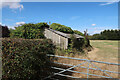
1
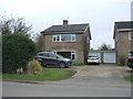
The Arches
House beside the byway to Belsar's Field. Spot the cat!
Image: © Keith Edkins
Taken: 6 Feb 2008
0.13 miles
2
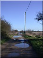
Puddles on the bridleway
If I go any further I'm going to need flippers!
Although it has a compacted surface, and is far more suitable for motor vehicles than many Byways round here (Image), this is technically only a Public Bridleway.
Image: © Keith Edkins
Taken: 6 Feb 2008
0.15 miles
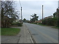
3

Towards Willingham from Haven Drove
Willingham church spire is on the skyline to the right of centre. A cool but bright April day was welcome after a generally bleak March in 2013.
Image: © John Sutton
Taken: 2 Apr 2013
0.16 miles
4
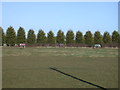
Grazing horses
Seen from the byway to Belsar's Field
Image: © Keith Edkins
Taken: 6 Feb 2008
0.19 miles
6
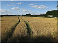
Wheat field by Rampton Road
On the edge of Willingham.
Image: © Hugh Venables
Taken: 17 Jul 2015
0.23 miles