IMAGES TAKEN NEAR TO
Watermead, CAMBRIDGE, CB23 8TN
Introduction
This page details the photographs taken nearby to Watermead, CB23 8TN by members of the Geograph project.
The Geograph project started in 2005 with the aim of publishing, organising and preserving representative images for every square kilometre of Great Britain, Ireland and the Isle of Man.

There are currently over 7.5m images from over14,400 individuals and you can help contribute to the project by visiting https://www.geograph.org.uk
Image Map
Images are licensed for reuse under creativecommons.org/licenses/by-sa/2.0
Notes
- Clicking on the map will re-center to the selected point.
- The higher the marker number, the further away the image location is from the centre of the postcode.
Image Listing (22 Images Found)
Images are licensed for reuse under creativecommons.org/licenses/by-sa/2.0
Image
Details
Distance
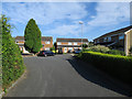
1
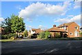
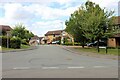
Watermead, Bar Hill
Watermead, from its junction with Crafts Way
Image: © Martin Tester
Taken: 2 May 2020
0.04 miles
2
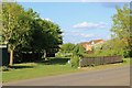
Grassy pathway, Bar Hill
This grassy pathway follows the course of a drainage channel running between the houses of Appletrees on the left & Watermead on the right. Seen from across Crafts Way.
Image: © Martin Tester
Taken: 2 May 2020
0.07 miles
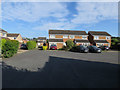
3
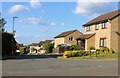
Hillcrest, Bar Hill
Hillcrest, from its junction with Crafts Way
Image: © Martin Tester
Taken: 2 May 2020
0.08 miles
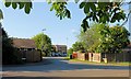
4
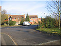
Crafts Way, Bar Hill, Cambs
View N of Crafts Hill and the perimeter road from Thruffle Way.
Image: © Rodney Burton
Taken: 10 Dec 2005
0.14 miles
7
Appletrees, Bar Hill
Appletrees, from its junction with Crafts Way
Image: © Martin Tester
Taken: 6 May 2020
0.16 miles
8
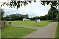
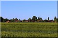
The school playing field, Bar Hill
Seen across the playing field is the old farm house.
Image: © Martin Tester
Taken: 25 Jun 2021
0.19 miles
9
Chestnut Rise, Bar Hill
Chestnut Rise, from its junction with Crafts Way
Image: © Martin Tester
Taken: 24 Aug 2020
0.20 miles
10
Thruffle Way, Bar Hill, from Pettitt?s Lane, Dry Drayton
When Bar Hill was planned the intention was that all housing should lie within a perimeter road. The developers had other ideas & as is so often the case the developers got their way & were allowed to build some housing outside it on Craft's Hill. This is the rear of Thruffle Way seen from the footpath at the end of Pettitt's Lane.
Image: © Martin Tester
Taken: 14 May 2020
0.20 miles