IMAGES TAKEN NEAR TO
Bennett Way, CAMBRIDGE, CB22 3FR
Introduction
This page details the photographs taken nearby to Bennett Way, CB22 3FR by members of the Geograph project.
The Geograph project started in 2005 with the aim of publishing, organising and preserving representative images for every square kilometre of Great Britain, Ireland and the Isle of Man.

There are currently over 7.5m images from over14,400 individuals and you can help contribute to the project by visiting https://www.geograph.org.uk
Image Map
Images are licensed for reuse under creativecommons.org/licenses/by-sa/2.0
Notes
- Clicking on the map will re-center to the selected point.
- The higher the marker number, the further away the image location is from the centre of the postcode.
Image Listing (39 Images Found)
Images are licensed for reuse under creativecommons.org/licenses/by-sa/2.0
Image
Details
Distance
1
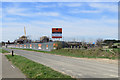
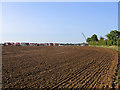
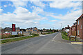
Sawston: coming soon
The Knights Field estate is going up on a triangular site on the road to Babraham at the eastern edge of Sawston.
Image: © John Sutton
Taken: 23 Mar 2020
0.02 miles
2
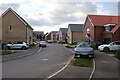
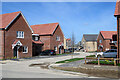
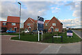
Bennett Way, Sawston
Lots of housing, not so many parking places.
Image: © Hugh Venables
Taken: 13 Apr 2023
0.03 miles
3
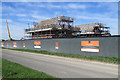
Sawston: new housing development off Babraham Road
The Knights Field estate is going up on a triangular site on the road to Babraham at the eastern edge of Sawston.
Image: © John Sutton
Taken: 23 Mar 2020
0.03 miles
4
Sawston: new building on Babraham Road
Approaching the eastern edge of Sawston on the footpath from Rowley Lane on a bright September morning.
Image: © John Sutton
Taken: 18 Sep 2020
0.04 miles
5
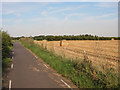
Towards the new edge of Sawston
Looking towards the new housing development on Babraham Road, on the eastern edge of Sawston, from the footpath from Rowley Lane. This was a lovely Indian summer morning in September.
Image: © John Sutton
Taken: 18 Sep 2020
0.05 miles
7
Sawston: Adeane Road
This is one of the first completed parts of a new estate, The Hawthorns, on the eastern edge of Sawston.
Image: © John Sutton
Taken: 27 Mar 2021
0.05 miles
8
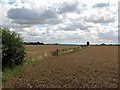
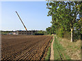
Wheatfields and where the railway was
The fence posts at the field boundary mark the course of the Cambridge-Colchester Stour Valley railway, which closed in 1967.
Image: © John Sutton
Taken: 12 Aug 2013
0.06 miles
9
Sawston: new estates on Babraham Road
The houses on the right have been built in the last few years and now another development is under way south of Babraham Road.
Image: © John Sutton
Taken: 2 Jul 2023
0.06 miles
10
New housing, Sawston
Called "The Hawthorns". In other news a hedge, with lots of hawthorn was cut down along the road by a neighbouring developer earlier in the week.
Image: © Hugh Venables
Taken: 13 Apr 2023
0.06 miles