IMAGES TAKEN NEAR TO
Withersfield Road, CAMBRIDGE, CB21 4SF
Introduction
This page details the photographs taken nearby to Withersfield Road, CB21 4SF by members of the Geograph project.
The Geograph project started in 2005 with the aim of publishing, organising and preserving representative images for every square kilometre of Great Britain, Ireland and the Isle of Man.

There are currently over 7.5m images from over14,400 individuals and you can help contribute to the project by visiting https://www.geograph.org.uk
Image Map (Loading...)


Getting Data...Please wait
Leaflet Map data © OpenStreetMap
Images are licensed for reuse under creativecommons.org/licenses/by-sa/2.0
Notes
- Clicking on the map will re-center to the selected point.
- The higher the marker number, the further away the image location is from the centre of the postcode.
Image Listing (16 Images Found)
Images are licensed for reuse under creativecommons.org/licenses/by-sa/2.0
Image
Details
Distance
1
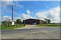
Former hangar, RAF Wratting Common
A WWII bomber airfield, whose runways were across to the right. Many intact buildings remain, put to other uses, but the runways are disused and partly taken up. The footpath starting here meanders across the airfield site.
Image: © Robin Webster
Taken: 8 Apr 2017
0.01 miles
2
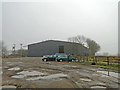
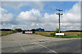
T2 hangar at ex-RAF Wratting
The station closed in April 1946 and many of the original building are still in use as industrial units.
Image: © Adrian S Pye
Taken: 18 Mar 2015
0.02 miles
3
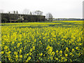
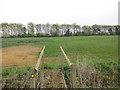
Footpath from Skipper's Lane
Or at least it should be; it hasn't been re-instated through the oil seed rape.
Image: © Hugh Venables
Taken: 17 Apr 2011
0.03 miles
4
Jelly Warehouse
Jelly Warehouse is based in one of the hangars of RAF Wratting Common, a Bomber Command Station during the Second World War. For more about RAF Wratting, see the very thorough http://www.wcnhistory.org.uk/overview.html .
Image: © John Sutton
Taken: 24 Sep 2022
0.04 miles
5

Footpath to Skipper's Lane
The bridge Image is there but the footpath isn't this season.
Image: © Hugh Venables
Taken: 17 Apr 2011
0.05 miles
6
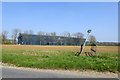
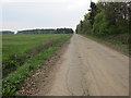
Footpath to Weston Woods Farm
Heading out across the former West Wratting airfield.
Image: © Hugh Venables
Taken: 17 Apr 2011
0.11 miles
7
Furniture store in a former RAF hangar
Home Brands is based in one of the hangars of RAF Wratting Common, a Bomber Command Station during the Second World War. For more about RAF Wratting, see http://www.wcnhistory.org.uk/overview.html .
Image: © John Sutton
Taken: 24 Sep 2022
0.16 miles
8
Old airfield track
Part of the former Wratting Common airfield that was used during WWII.
Image: © Hugh Venables
Taken: 17 Apr 2011
0.22 miles
9
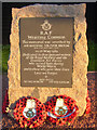
RAF West Wratting Remembered
The view is NE to Weston Woods Farm. The memorial on the right is to those who served at RAF West Wratting in WWII. See other picture for inscription
Image: © mike
Taken: 17 Sep 2005
0.22 miles