IMAGES TAKEN NEAR TO
Streetly End, CAMBRIDGE, CB21 4RR
Introduction
This page details the photographs taken nearby to Streetly End, CB21 4RR by members of the Geograph project.
The Geograph project started in 2005 with the aim of publishing, organising and preserving representative images for every square kilometre of Great Britain, Ireland and the Isle of Man.

There are currently over 7.5m images from over14,400 individuals and you can help contribute to the project by visiting https://www.geograph.org.uk
Image Map (Loading...)


Getting Data...Please wait
Leaflet Map data © OpenStreetMap
Images are licensed for reuse under creativecommons.org/licenses/by-sa/2.0
Notes
- Clicking on the map will re-center to the selected point.
- The higher the marker number, the further away the image location is from the centre of the postcode.
Image Listing (9 Images Found)
Images are licensed for reuse under creativecommons.org/licenses/by-sa/2.0
Image
Details
Distance
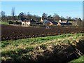
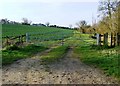
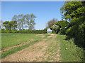
2
The view from the entrance to Streetly Hall Estate
Image: © Robert Edwards
Taken: 15 Jan 2007
0.08 miles
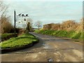
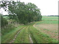
3
Footpath Off Country Road
Footpath leading to West Wickham, Cambridgeshire.
Image: © Keith Evans
Taken: 27 Sep 2012
0.14 miles
4
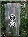
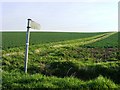
Footpath Sign
Footpath sign near to Horseheath, Cambridgeshire.
Image: © Keith Evans
Taken: 9 Oct 2014
0.15 miles
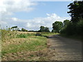
7
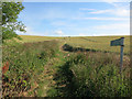
Footpath to West Wickham
A near repeat of Image but in a different season and with different crops in the fields.
Image: © Hugh Venables
Taken: 7 Jul 2014
0.17 miles
8
Old Roman Road
Part of the old Roman Road and now Harcamlow Way looking east near to Horseheath, Cambridgeshire.
Image: © Keith Evans
Taken: 9 Oct 2014
0.17 miles
9
Roman Road past Streetly Hall
This stretch also forms part of the Harcamlow Way.
Image: © Hugh Venables
Taken: 1 May 2011
0.19 miles