IMAGES TAKEN NEAR TO
Horseheath, CAMBRIDGE, CB21 4QD
Introduction
This page details the photographs taken nearby to CB21 4QD by members of the Geograph project.
The Geograph project started in 2005 with the aim of publishing, organising and preserving representative images for every square kilometre of Great Britain, Ireland and the Isle of Man.

There are currently over 7.5m images from over14,400 individuals and you can help contribute to the project by visiting https://www.geograph.org.uk
Image Map (Loading...)


Getting Data...Please wait
Leaflet Map data © OpenStreetMap
Images are licensed for reuse under creativecommons.org/licenses/by-sa/2.0
Notes
- Clicking on the map will re-center to the selected point.
- The higher the marker number, the further away the image location is from the centre of the postcode.
Image Listing (37 Images Found)
Images are licensed for reuse under creativecommons.org/licenses/by-sa/2.0
Image
Details
Distance
1
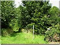
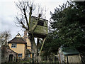
Footpath to Streetly End
The Horseheath end of a path across fields.
Image: © John Sutton
Taken: 11 Aug 2012
0.01 miles
2
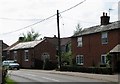
Horseheath: houses on West Wickham Road
The Old Chapel, on the left, is part of a larger house.
Image: © John Sutton
Taken: 11 Aug 2012
0.02 miles
3
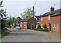
Horseheath: round the corner
West Wickham Road on the last morning of April.
Image: © John Sutton
Taken: 30 Apr 2023
0.02 miles
4

Former chapel, Horseheath
Built in 1861. Now a b&b.
Image: © Bikeboy
Taken: 28 Jun 2014
0.02 miles
5
Horseheath, All Saints
Frances Baines, died 1846 at the age of 33.
Her inscription reads:
She filled the office of schoolmistress in this parish for nine years, to the duties of which situation she devoted herself with diligence and assiduity beyond her strength, and in this cause having passed six months at an Infant School training Institution to qualify herself further as a teacher of the younger children more especially according to the most approved method. She suffered from the close application there required, and ultimately fell a sacrifice, to her praiseworthy exertions. In grateful recollection of benefits received, her sorrowing scholars have erected this monument.
http://www.druidic.org/camchurch/churches/horseheath.htm
Image: © mym
Taken: 2 Feb 2004
0.03 miles
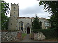
7
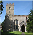
Horseheath: All Saints - south side
The tall tower has the sort of stepped battlements common in nearby Suffolk. The south porch dates from the restoration of 1875. Nikolaus Pevsner thought the large Perpendicular nave windows made "a veritable glasshouse". The brick battlements date from the lowering of the once taller nave roof - there is evidence of its steep pitch on the east wall of the tower.
Image: © John Sutton
Taken: 11 Aug 2012
0.07 miles
8
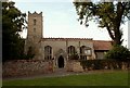
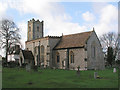
All Saints; the parish church of Horseheath
It was built between the 14th and 15th centuries and the exterior was over-restored in 1875 by Rowe. The interior houses many fine brasses and monuments, plus an oak screen.
Image: © Robert Edwards
Taken: 8 Aug 2007
0.07 miles
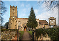
10
All Saints, Horseheath
The church of All Saints, Horseheath, Cambridgeshire. For more info see http://www.druidic.org/camchurch/churches/horseheath.htm and for interesting grave stone see http://www.geograph.org.uk/photo/2604605
Image: © Keith Evans
Taken: 15 Sep 2011
0.08 miles