IMAGES TAKEN NEAR TO
The Brambles, CAMBRIDGE, CB21 4ED
Introduction
This page details the photographs taken nearby to The Brambles, CB21 4ED by members of the Geograph project.
The Geograph project started in 2005 with the aim of publishing, organising and preserving representative images for every square kilometre of Great Britain, Ireland and the Isle of Man.

There are currently over 7.5m images from over14,400 individuals and you can help contribute to the project by visiting https://www.geograph.org.uk
Image Map (Loading...)


Getting Data...Please wait
Leaflet Map data © OpenStreetMap
Images are licensed for reuse under creativecommons.org/licenses/by-sa/2.0
Notes
- Clicking on the map will re-center to the selected point.
- The higher the marker number, the further away the image location is from the centre of the postcode.
Image Listing (56 Images Found)
Images are licensed for reuse under creativecommons.org/licenses/by-sa/2.0
Image
Details
Distance
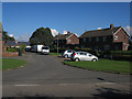
2
Balsham: a stinkpipe on West Wickham Road
The sewer vent pipe on the right, near the eastern edge of the village, is the concrete-cased type found in a number of Cambridgeshire villages.
Image: © John Sutton
Taken: 8 Jul 2022
0.04 miles

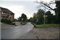
8
Balsham: Princes Close
Council-built houses off West Wickham Road at the eastern end of the village.
Image: © John Sutton
Taken: 31 Aug 2018
0.07 miles
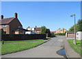
10
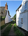
Balsham: path to allotments
White walls and thatch: houses on West Wickham Road, photographed on a bright late-summer morning.
Image: © John Sutton
Taken: 31 Aug 2018
0.09 miles