IMAGES TAKEN NEAR TO
Harcombe Road, CAMBRIDGE, CB1 9PD
Introduction
This page details the photographs taken nearby to Harcombe Road, CB1 9PD by members of the Geograph project.
The Geograph project started in 2005 with the aim of publishing, organising and preserving representative images for every square kilometre of Great Britain, Ireland and the Isle of Man.

There are currently over 7.5m images from over14,400 individuals and you can help contribute to the project by visiting https://www.geograph.org.uk
Image Map
Images are licensed for reuse under creativecommons.org/licenses/by-sa/2.0
Notes
- Clicking on the map will re-center to the selected point.
- The higher the marker number, the further away the image location is from the centre of the postcode.
Image Listing (51 Images Found)
Images are licensed for reuse under creativecommons.org/licenses/by-sa/2.0
Image
Details
Distance
2

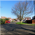
A maze of twisty cul-de-sacs, all alike
Cherry Hinton has grown considerably since the 1980s, and is now full of curved roads with numerous small sideroads, filled with near-identical brick houses. Very disorientating.
Image: © Colin Bell
Taken: 1 Apr 2008
0.13 miles
4
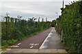
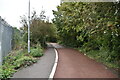
Cherry Hinton: cycling past a corrugated fence
The route runs from Cherry Hinton High Street level crossing to Brookfields and Mill Road (ahead). The houses are on Kathleen Elliot Way, off Coldhams Lane.
Image: © John Sutton
Taken: 22 Jan 2019
0.14 miles
5
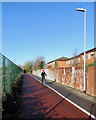
Cherry Hinton to Brookfields
This path starts at Railway Street, off Cherry Hinton High Street, and leads to Brookfields and Mill Road. The houses on the right are on Wolsey Way, approached from Coldhams Lane.
Image: © John Sutton
Taken: 22 Jan 2019
0.14 miles
7
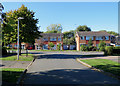
Cherry Hinton: Doggett Road
A sunny October afternoon in suburban Cambridge.
Image: © John Sutton
Taken: 4 Oct 2018
0.15 miles
8
Cherry Hinton: Daws Close
Suburban Cambridge on one of the unusually warm and bright days at the end of February 2019.
Image: © John Sutton
Taken: 27 Feb 2019
0.16 miles
9
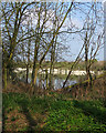
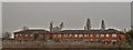
Across the chalk pits
The chalk pits - now fishing lakes - served the Norman cement works, which closed in 1984. This view over Cherry Hinton Brook is from Snakey Path, near St Bede's Crescent.
Image: © John Sutton
Taken: 30 Mar 2019
0.16 miles
10
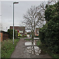
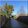
Cherry Hinton: puddles on Daws Lane
Looking towards Sidney Farm Road on a drab January morning. There had been a lot of rain the evening before.
Image: © John Sutton
Taken: 14 Jan 2020
0.16 miles