IMAGES TAKEN NEAR TO
Colville Road, CAMBRIDGE, CB1 9BU
Introduction
This page details the photographs taken nearby to Colville Road, CB1 9BU by members of the Geograph project.
The Geograph project started in 2005 with the aim of publishing, organising and preserving representative images for every square kilometre of Great Britain, Ireland and the Isle of Man.

There are currently over 7.5m images from over14,400 individuals and you can help contribute to the project by visiting https://www.geograph.org.uk
Image Map
Images are licensed for reuse under creativecommons.org/licenses/by-sa/2.0
Notes
- Clicking on the map will re-center to the selected point.
- The higher the marker number, the further away the image location is from the centre of the postcode.
Image Listing (158 Images Found)
Images are licensed for reuse under creativecommons.org/licenses/by-sa/2.0
Image
Details
Distance
1
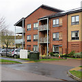
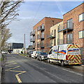
Cherry Hinton: Upperhall Court
The balconies of these flats on Colville Road have glass panels etched with sections of a large-scale map of Cherry Hinton. Image] shows some of them a little more closely.
Image: © John Sutton
Taken: 23 Jan 2018
0.01 miles
2
Cherry Hinton: Upperhall Court
A development opposite Colville Primary School.
Image: © John Sutton
Taken: 24 Jun 2017
0.02 miles
3
Cherry Hinton Medical Centre
The Fisher's Lane surgery of the Cherry Hinton and Brookside practice, photographed on flu-jab morning.
Image: © John Sutton
Taken: 24 Sep 2016
0.03 miles
4
Cherry Hinton: new houses on Fisher's Lane
A group of houses is being built on the land next to the medical centre.
Image: © John Sutton
Taken: 24 Sep 2016
0.03 miles
5

Cherry Hinton: Wenvoe Close to Poppy Close
Cherry Hinton changed from a village on the edge of Cambridge to a populous suburb in the second half of the twentieth century and has continued to expand in the twenty-first. Poppy Close is a newish development - Image] shows building work in 2016.
Image: © John Sutton
Taken: 5 Jan 2022
0.04 miles
6

Cherry Hinton: geographical balconies
The balconies of these flats on Colville Road have glass panels etched with sections of a large-scale map of Cherry Hinton.
Image: © John Sutton
Taken: 23 Jan 2018
0.04 miles
7

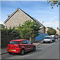
Cherry Hinton: Fisher's Lane
Suburban Cambridge in August.
Image: © John Sutton
Taken: 12 Aug 2016
0.04 miles
8
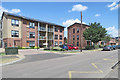
Cherry Hinton: the changing face of Colville Road
These as-yet-unfinished flats have acquired balconies since I photographed them in September 2022: Image
Image: © John Sutton
Taken: 4 Jan 2023
0.04 miles
9

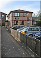
Cherry Hinton: Talbot House
Sheltered housing at the corner of Fisher's Lane and Wenvoe Close, photographed on a bright January morning.
Image: © John Sutton
Taken: 5 Jan 2022
0.04 miles
10
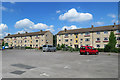
Cherry Hinton: post-war flats on Colville Road
Cherry Hinton expanded enormously in the years after the Second World War and the village is now a large suburb of Cambridge.
Image: © John Sutton
Taken: 14 Jun 2020
0.04 miles