IMAGES TAKEN NEAR TO
Mowbray Road, CAMBRIDGE, CB1 7SY
Introduction
This page details the photographs taken nearby to Mowbray Road, CB1 7SY by members of the Geograph project.
The Geograph project started in 2005 with the aim of publishing, organising and preserving representative images for every square kilometre of Great Britain, Ireland and the Isle of Man.

There are currently over 7.5m images from over14,400 individuals and you can help contribute to the project by visiting https://www.geograph.org.uk
Image Map (Loading...)


Getting Data...Please wait
Leaflet Map data © OpenStreetMap
Images are licensed for reuse under creativecommons.org/licenses/by-sa/2.0
Notes
- Clicking on the map will re-center to the selected point.
- The higher the marker number, the further away the image location is from the centre of the postcode.
Image Listing (214 Images Found)
Images are licensed for reuse under creativecommons.org/licenses/by-sa/2.0
Image
Details
Distance
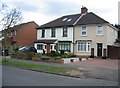
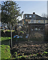
1
Mowbray Road: house conversion
Some of the outside walls and all of the interior ones have been removed and steel girders support what remains.
Image: © John Sutton
Taken: 13 Jan 2020
0.00 miles
2
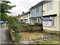
Mowbray Road: Thank You
"Thank you to the amazing NHS staff and all those working tirelessly on the front line to keep us all safe" reads this banner on a bay window in Mowbray Road (one of the main approaches to Addenbrooke's and Papworth Hospitals). This is one of millions of expressions of support for NHS, care and other essential workers, from all sections of the community, which have appeared all over the country during the coronavirus pandemic emergency.
Image: © John Sutton
Taken: 28 Apr 2020
0.01 miles
3
Mowbray Road: a lull in Storm Ciaran
Storm Ciaran brought exceptionally high winds, a lot of rain, flooding, power cuts and destruction to parts of the country on 2 November 2023. Cambridge was largely spared: in mid morning overnight rain had ceased, but this proved a lull before a lot more rain later in the day.
Image: © John Sutton
Taken: 2 Nov 2023
0.02 miles
4
At the Mowbray Road end of the Rock Allotments
The Glebe Road plot is the largest of the Rock Allotment Society's holdings. The front of the house in the background appears in Image] (January 2019).
Image: © John Sutton
Taken: 7 Feb 2020
0.02 miles
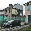
5
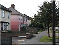
Mowbray Road: striped houses
A jolly colour scheme for a pair of former council houses.
Image: © John Sutton
Taken: 25 Sep 2011
0.02 miles
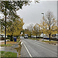
6
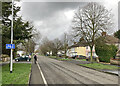
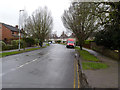
On the Mowbray Road cycle lane
Just past the Holbrook Road turn on a grey and wintry March afternoon. (The cyclist/photographer was stationary.)
Image: © John Sutton
Taken: 5 Mar 2024
0.03 miles
8
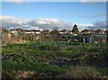
Rock Allotments in January
Part of the Rock Allotment Society's Glebe Road plot, largely deserted at Sunday lunchtime. The houses in the background are on Mowbray Road.
Image: © John Sutton
Taken: 19 Jan 2014
0.07 miles
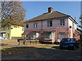
9
Glebe Road
Part of a large inter-war council housing development on the south-east side of Cambridge.
Image: © Alan Murray-Rust
Taken: 27 Dec 2014
0.07 miles