IMAGES TAKEN NEAR TO
Church Hill, SAFFRON WALDEN, CB10 2HF
Introduction
This page details the photographs taken nearby to Church Hill, CB10 2HF by members of the Geograph project.
The Geograph project started in 2005 with the aim of publishing, organising and preserving representative images for every square kilometre of Great Britain, Ireland and the Isle of Man.

There are currently over 7.5m images from over14,400 individuals and you can help contribute to the project by visiting https://www.geograph.org.uk
Image Map
Images are licensed for reuse under creativecommons.org/licenses/by-sa/2.0
Notes
- Clicking on the map will re-center to the selected point.
- The higher the marker number, the further away the image location is from the centre of the postcode.
Image Listing (23 Images Found)
Images are licensed for reuse under creativecommons.org/licenses/by-sa/2.0
Image
Details
Distance
1
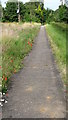
Footpath heading NE down into Ashdon
This footpath runs parallel to the road that drops down into the valley where the village of Ashdon is located. Prior to the Black Death in the 14th century the village was at the top of the hill SW of the current location. The survivors moved to the present location. The church remains in its original setting on the hill
Image: © Alan Hawkes
Taken: 13 Jul 2008
0.04 miles
2
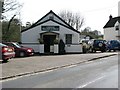
Ashdon Village Museum
Run by enthusiasts in the village, sparked off by the discovery of a large amount of Civil War artifacts in the area.
Image: © Colin Bell
Taken: 30 Mar 2008
0.05 miles
4
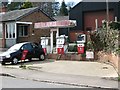
Derelict petrol station
Surprisingly, given the antiquated equipment, this was in operation until a year or two ago.
Image: © Colin Bell
Taken: 30 Mar 2008
0.11 miles
5
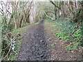
Muddy path near Ashdon
This path runs alongside the River Bourne.
Image: © David Beresford
Taken: 28 Mar 2013
0.12 miles
6
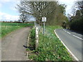
Old Milestone
Old milepost at Ashdon, Essex. For close up view see http://www.geograph.org.uk/photo/2884992
Image: © Keith Evans
Taken: 4 Apr 2012
0.13 miles

8
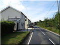
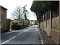
Footpath And Road
Separate footpath and road at Ashdon, Essex.
Image: © Keith Evans
Taken: 11 Apr 2012
0.16 miles
9
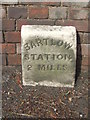
Old Milestone
Old milepost at Ashdon, Essex. For overall view see http://www.geograph.org.uk/photo/2884996
Image: © Keith Evans
Taken: 4 Apr 2012
0.16 miles
10
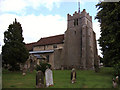
All Saints' Church, Ashdon, Essex
How long there has been a church on the present site is unknown, but there was certainly one in existence by the 10th century. It was probably built of wood. There is a reasonable possibility that the church was rebuilt in stone early in the 11th century. The oldest part of the present church, which is dedicated to All Saints, is the long and spacious chancel which was probably built in the 13th century, flanked by a large chapel on the south side dating from about 1320.
Image: © Peter Stack
Taken: 25 Jun 2011
0.16 miles