IMAGES TAKEN NEAR TO
Potters Loaning, ALSTON, CA9 3TP
Introduction
This page details the photographs taken nearby to Potters Loaning, CA9 3TP by members of the Geograph project.
The Geograph project started in 2005 with the aim of publishing, organising and preserving representative images for every square kilometre of Great Britain, Ireland and the Isle of Man.

There are currently over 7.5m images from over14,400 individuals and you can help contribute to the project by visiting https://www.geograph.org.uk
Image Map
Images are licensed for reuse under creativecommons.org/licenses/by-sa/2.0
Notes
- Clicking on the map will re-center to the selected point.
- The higher the marker number, the further away the image location is from the centre of the postcode.
Image Listing (42 Images Found)
Images are licensed for reuse under creativecommons.org/licenses/by-sa/2.0
Image
Details
Distance
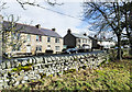
1
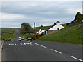
A689, Alston
At Clitheroe Cottages, on the edge of the town.
Image: © Andrew Smith
Taken: 4 Jun 2006
0.08 miles
3
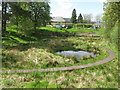
Site of Fairhill Old Dam, Alston
This part of Fairhill used to be a reservoir holding water from the mill race which was then used to power various industries in Alston. As this is a very wet area it was decided to create an environmental area. Frogs and newts used to live here and frogs have begun to return. Bats are sometimes seen in the evenings and rabbits are often visible.
Image: © G Laird
Taken: 13 May 2014
0.13 miles
5
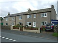
Houses on Chapel Street
Houses on the north side of Chapel Street in Alston seen from the car park at Fair Hill.
Image: © Trevor Littlewood
Taken: 2 Mar 2020
0.14 miles
6
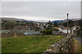
Townhead, Alston
Looking down on the top end of the town from the road which leaves towards Garrigill.
Image: © Bill Boaden
Taken: 6 Mar 2014
0.14 miles
8
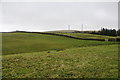
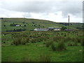
Farmland on Alston Moor
Looking uphill from the very southern fringe of Alston.
Image: © Bill Boaden
Taken: 6 Mar 2014
0.15 miles
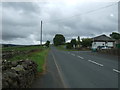
10
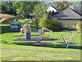
Children's play area at Alston
By Nenthead Road.
Image: © Oliver Dixon
Taken: 24 Sep 2018
0.16 miles