IMAGES TAKEN NEAR TO
Nenthead Road, ALSTON, CA9 3SN
Introduction
This page details the photographs taken nearby to Nenthead Road, CA9 3SN by members of the Geograph project.
The Geograph project started in 2005 with the aim of publishing, organising and preserving representative images for every square kilometre of Great Britain, Ireland and the Isle of Man.

There are currently over 7.5m images from over14,400 individuals and you can help contribute to the project by visiting https://www.geograph.org.uk
Image Map (Loading...)


Getting Data...Please wait
Leaflet Map data © OpenStreetMap
Images are licensed for reuse under creativecommons.org/licenses/by-sa/2.0
Notes
- Clicking on the map will re-center to the selected point.
- The higher the marker number, the further away the image location is from the centre of the postcode.
Image Listing (246 Images Found)
Images are licensed for reuse under creativecommons.org/licenses/by-sa/2.0
Image
Details
Distance
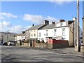
2
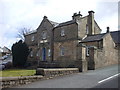
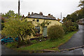
Houses on Chapel Street
Houses on the north side of Chapel Street in Alston seen from the car park at Fair Hill.
Image: © Trevor Littlewood
Taken: 2 Mar 2020
0.02 miles
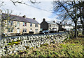
3
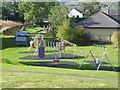
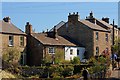
Children's play area at Alston
By Nenthead Road.
Image: © Oliver Dixon
Taken: 24 Sep 2018
0.04 miles
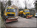
7
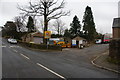
Alston Depot
A small Cumbria County Council depot, but a good place to keep a snowplough.
Image: © Bill Boaden
Taken: 6 Mar 2014
0.07 miles
10
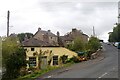
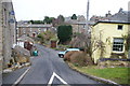
Nenthead Road, Alston
Taken from the just visible junction with Overburn.
Image: © David Kemp
Taken: 4 Aug 2023
0.07 miles