IMAGES TAKEN NEAR TO
Nenthead, ALSTON, CA9 3PH
Introduction
This page details the photographs taken nearby to CA9 3PH by members of the Geograph project.
The Geograph project started in 2005 with the aim of publishing, organising and preserving representative images for every square kilometre of Great Britain, Ireland and the Isle of Man.

There are currently over 7.5m images from over14,400 individuals and you can help contribute to the project by visiting https://www.geograph.org.uk
Image Map
Images are licensed for reuse under creativecommons.org/licenses/by-sa/2.0
Notes
- Clicking on the map will re-center to the selected point.
- The higher the marker number, the further away the image location is from the centre of the postcode.
Image Listing (92 Images Found)
Images are licensed for reuse under creativecommons.org/licenses/by-sa/2.0
Image
Details
Distance
1
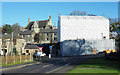
Shrouded church, Nenthead
The Methodist Church at Nenthead is being restored and converted to multiple community uses. (November 2017.) A Heritage Lottery Grant of almost £1.7 million is providing the main funding for the project.
http://www.nentheadchapel.co.uk
Image: © Trevor Littlewood
Taken: 5 Nov 2017
0.04 miles

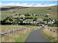
5
Nenthead Village Hall
A non-denominational school was built by London Lead Co. by 1818; this was replaced by the figured imposing new building in 1864 which is now used as Nenthead village hall. Inside there is a tablet to Robert Stagg, the agent for the London Lead Company, who started the first school in the Quaker's model mining village of Nenthead.
Image: © Andrew Curtis
Taken: 20 Oct 2020
0.04 miles
6
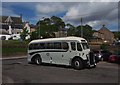
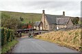
Travel back to the future
This is a Crossley bus registration no. FUN 319 lovingly restored outside Wright's bus depot at Nenthead, after a return trip to Alston down the Nent valley. Nenthead is a stop on Isaac's Tea Trail and where there is a good network of local bus services.
Image: © Roger Morris
Taken: 15 Jul 2012
0.04 miles
7

North Pennine Cycles, Nenthead
A veritable Aladdin's cave of cycling bits and pieces http://www.northpenninecycles.co.uk/shop-bicycle-store
The main part of the business is as a repair shop and supplier of parts and accessories to cyclists on the C2C route which passes through the village.
The building is attached to the former Nenthead Chapel which is presently encased in corrugated iron sheeting. The building is undergoing an ambitious restoration project which will provide space for a cafe, community hub, information centre and gallery for craftspeople http://www.nentheadchapel.co.uk/.
Image: © Oliver Dixon
Taken: 20 Feb 2018
0.05 miles


10
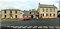
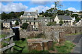
Nenthead
The Miners Arms, left of the Wesleyan Church Image, was bought by the London Lead Company in 1823. They reduced the rent as "the miners preferred books to drink". The hotel is currently for sale (2020).
Hillersdon Terrace can be seen between the two buildings. It was named after John Hillersdon of the London Lead Company. The terrace consisting of a sequence of seven housing blocks spread along the contour a little way up the valley side and parallel to the river. The blocks vary in size and arrangement of accommodation, intended to provide high-quality accommodation for management and workers alike, from the detached house for the surgeon, the semi-detached houses for the mill agent and school master, to the smelters who were housed in one-bay terraced houses in three rows of four.
English Heritage: The Parish of Alston Moor, Cumbria - Historic Area Assessment (2010).
Image: © Andrew Curtis
Taken: 20 Oct 2020
0.05 miles