IMAGES TAKEN NEAR TO
ALSTON, CA9 3NH
Introduction
This page details the photographs taken nearby to CA9 3NH by members of the Geograph project.
The Geograph project started in 2005 with the aim of publishing, organising and preserving representative images for every square kilometre of Great Britain, Ireland and the Isle of Man.

There are currently over 7.5m images from over14,400 individuals and you can help contribute to the project by visiting https://www.geograph.org.uk
Image Map
Images are licensed for reuse under creativecommons.org/licenses/by-sa/2.0
Notes
- Clicking on the map will re-center to the selected point.
- The higher the marker number, the further away the image location is from the centre of the postcode.
Image Listing (12 Images Found)
Images are licensed for reuse under creativecommons.org/licenses/by-sa/2.0
Image
Details
Distance
1
Ayle Townhead
Behind Black Fell rises at the head of Gilderdale.
Image: © Andrew Smith
Taken: 7 Mar 2006
0.03 miles
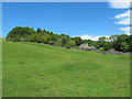
3
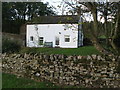
Cottage at Ayle
With some recent extensions.
Image: © Oliver Dixon
Taken: 29 Jul 2014
0.11 miles
4
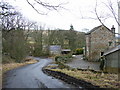
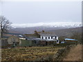
Ayle
Aylebank Barn is on the right with Ayle House in the trees beyond. There are six residences in the hamlet.
Image: © Andrew Smith
Taken: 7 Mar 2006
0.15 miles
6
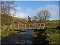
Footbridge over Ayle Burn
This is the higher of two footbridges swept away in a flash flood in August 2002,shortly before the opening of Isaac's Tea Trail and at the end of the foot mouth outbreak. The replacement bridge in the photograph was completed in 2005 and has been placed about 25 metres down stream of the original crossing point, where a buttress can still be seen.
Image: © Roger Morris
Taken: 21 Jan 2009
0.17 miles
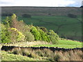
8
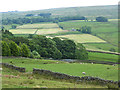
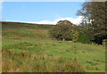
Valley of the Ayle Burn
A tributary valley of the South Tyne.
Image: © Oliver Dixon
Taken: 29 Jul 2014
0.17 miles
9
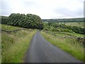
Woods near Ayle
The hamlet of Ayle, in a tributary valley of the South Tyne, is almost completely surrounded by woodland.
Image: © Oliver Dixon
Taken: 15 Jul 2008
0.17 miles