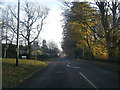
IMAGES TAKEN NEAR TO
ALSTON, CA9 3JZ
Introduction
This page details the photographs taken nearby to CA9 3JZ by members of the Geograph project.
The Geograph project started in 2005 with the aim of publishing, organising and preserving representative images for every square kilometre of Great Britain, Ireland and the Isle of Man.

There are currently over 7.5m images from over14,400 individuals and you can help contribute to the project by visiting https://www.geograph.org.uk
Image Map
Images are licensed for reuse under creativecommons.org/licenses/by-sa/2.0
Notes
- Clicking on the map will re-center to the selected point.
- The higher the marker number, the further away the image location is from the centre of the postcode.
Image Listing (13 Images Found)
Images are licensed for reuse under creativecommons.org/licenses/by-sa/2.0
Image
Details
Distance
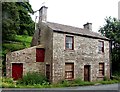
1
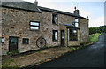
Head
The cottage at Head on The Loaning.
Image: © Peter McDermott
Taken: 14 Aug 2011
0.11 miles
2
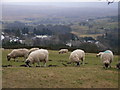
Sheep above Alston
The view from North Loaning.
Image: © Andrew Smith
Taken: 7 Feb 2006
0.16 miles
3
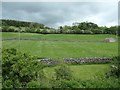
Farmland north of Alston
Above the east bank of the River South Tyne.
Image: © Christine Johnstone
Taken: 5 Jun 2019
0.17 miles
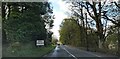
5
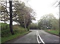
Road junction with minor road near Coatlith Hill
Image: © John Firth
Taken: 19 May 2013
0.19 miles
6
Tollhouse by the A686, north of Alston
Tollhouse by the A686, in the parish of Alston Moor (Eden District), The Gatehouse, Alston, CA9 3ND.
Grade II listed.
List Entry Number: 1326653 https://historicengland.org.uk/listing/the-list/list-entry/1326653
To be surveyed
Milestone Society National ID: CB.ALS
Image: © Milestone Society
Taken: Unknown
0.19 miles
7
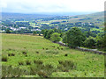
Hillside above Alston
The town of Alston in South Tynedale can be seen in the floor of the valley. The minor road to the right in the foreground is the Loaning.
Image: © Oliver Dixon
Taken: 29 Jul 2014
0.20 miles
9
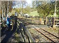
Crossing on the South Tyne Trail
Parallel to the South Tynedale Railway, a permissive footpath occupies part of the former railbed, which carries both the South Tyne Trail and the River Tyne Trail, sponsored by Daft as a Brush. Here the permissive path crosses from the west to the east side of the railway.
Image: © Oliver Dixon
Taken: 4 Nov 2020
0.22 miles
10
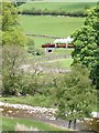
South Tynedale Railway nr Alston
Looking NE from the Pennine Way near Harbut Lodge. One of the filter beds of the Alston sewage works is just visible above the tree in the foreground.
Image: © Dave Dunford
Taken: 29 May 2005
0.22 miles