IMAGES TAKEN NEAR TO
Garrigill, ALSTON, CA9 3DG
Introduction
This page details the photographs taken nearby to CA9 3DG by members of the Geograph project.
The Geograph project started in 2005 with the aim of publishing, organising and preserving representative images for every square kilometre of Great Britain, Ireland and the Isle of Man.

There are currently over 7.5m images from over14,400 individuals and you can help contribute to the project by visiting https://www.geograph.org.uk
Image Map (Loading...)


Getting Data...Please wait
Leaflet Map data © OpenStreetMap
Images are licensed for reuse under creativecommons.org/licenses/by-sa/2.0
Notes
- Clicking on the map will re-center to the selected point.
- The higher the marker number, the further away the image location is from the centre of the postcode.
Image Listing (36 Images Found)
Images are licensed for reuse under creativecommons.org/licenses/by-sa/2.0
Image
Details
Distance
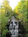
2
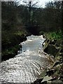
Garrigill Burn
Flowing down from Thortergill Falls near Garrigill
Image: © Christine Westerback
Taken: 7 Apr 2007
0.01 miles
3
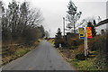
Road to Nenthead
The road rises from South Tynedale to the B6277 close to Garrigill Burn.
Image: © Bill Boaden
Taken: 6 Mar 2014
0.02 miles

5

Garrigill Burn above Lowhouses Bridge
The waterfall has been artificially engineered.
Image: © Bill Boaden
Taken: 6 Mar 2014
0.03 miles
6
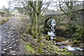
Garrigill Burn and Lowhouses Bridge
The burn is tumbling down to the South Tyne just below Garrigill. The bridge carries the main route into Garrigill.
Image: © Bill Boaden
Taken: 6 Mar 2014
0.03 miles
8
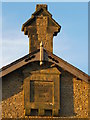
Datestone on the former Wesleyan chapel, Lowhouses near Garrigill
The location of this date stone is shown in Image
Image: © Mike Quinn
Taken: 9 Oct 2012
0.04 miles
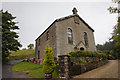
10
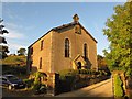
Former Wesleyan chapel, Lowhouses near Garrigill
Image: © Mike Quinn
Taken: 9 Oct 2012
0.04 miles