IMAGES TAKEN NEAR TO
ALSTON, CA9 3DD
Introduction
This page details the photographs taken nearby to CA9 3DD by members of the Geograph project.
The Geograph project started in 2005 with the aim of publishing, organising and preserving representative images for every square kilometre of Great Britain, Ireland and the Isle of Man.

There are currently over 7.5m images from over14,400 individuals and you can help contribute to the project by visiting https://www.geograph.org.uk
Image Map
Images are licensed for reuse under creativecommons.org/licenses/by-sa/2.0
Notes
- Clicking on the map will re-center to the selected point.
- The higher the marker number, the further away the image location is from the centre of the postcode.
Image Listing (30 Images Found)
Images are licensed for reuse under creativecommons.org/licenses/by-sa/2.0
Image
Details
Distance
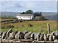
1
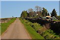
High Plains
Looking up the lane towards the lodge, which is the site of the Alston Training & Adventure Centre seehttp://www.alstontraining.co.uk/.
Image: © Mick Garratt
Taken: 30 Apr 2011
0.00 miles
2
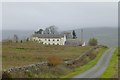
High Plains Lodge
High above the River South Tyne.
Former Adventure Centre.
Image: © Russel Wills
Taken: 23 Oct 2018
0.01 miles
3
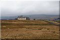
Alston Training and Adventure Centre
An outdoor activity centre in quite a remote moorland location above the South Tyne.
Image: © Bill Boaden
Taken: 6 Mar 2014
0.01 miles
4
High Plains Lodge
Home of the Alston Training & Adventure Centre.
Image: © Andrew Curtis
Taken: 29 May 2015
0.01 miles
5
High Plains Lodge
Formerly the family-run Alston Training and Adventure Centre opened in 1988. Understood to now be permanently closed.
Image: © Oliver Dixon
Taken: 24 Sep 2018
0.02 miles
8
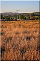
Electricity Transmission Poles
Viewed from High Plains and looking towards the golf club.
Image: © Mick Garratt
Taken: 30 Apr 2011
0.12 miles
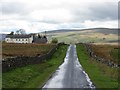
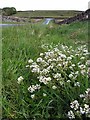
9
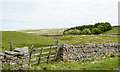
Dry stone wall with gate near to High Plains
The wall is on the north side of a minor road, which gives access to various properties. The B6277 runs between the walls below the trees; it connects Alston with Teesdale.
Image: © Trevor Littlewood
Taken: 27 May 2020
0.14 miles
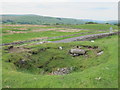
10
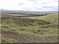
Old mine workings above High Plains Lodge
Seen from the Alston to Teesdale Road, high above South Tynedale.
Image: © Oliver Dixon
Taken: 20 Feb 2018
0.16 miles