IMAGES TAKEN NEAR TO
ALSTON, CA9 3BL
Introduction
This page details the photographs taken nearby to CA9 3BL by members of the Geograph project.
The Geograph project started in 2005 with the aim of publishing, organising and preserving representative images for every square kilometre of Great Britain, Ireland and the Isle of Man.

There are currently over 7.5m images from over14,400 individuals and you can help contribute to the project by visiting https://www.geograph.org.uk
Image Map
Images are licensed for reuse under creativecommons.org/licenses/by-sa/2.0
Notes
- Clicking on the map will re-center to the selected point.
- The higher the marker number, the further away the image location is from the centre of the postcode.
Image Listing (21 Images Found)
Images are licensed for reuse under creativecommons.org/licenses/by-sa/2.0
Image
Details
Distance
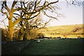

4
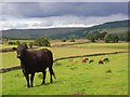
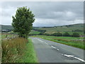
Pastures, Alston
Looking towards Alston. The road from Leadgate is at the cow's head-height.
Image: © Andrew Smith
Taken: 20 Jul 2008
0.17 miles
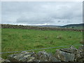
7
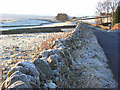
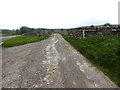
The Alston to Leadgate road
With dry-stone walls on a frosty morning. There is just a hint of the presence of Cross Fell in the background.
Image: © Andrew Smith
Taken: 30 Nov 2008
0.18 miles
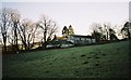
8
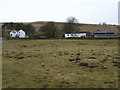
Bayles
Middle Bayles and Hill House behind.
Image: © Andrew Smith
Taken: 7 Mar 2006
0.19 miles
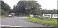
10
Driveway to Bayles Farm
Off the A686.
Image: © Oliver Dixon
Taken: 24 Sep 2018
0.19 miles