IMAGES TAKEN NEAR TO
Castle Carrock, BRAMPTON, CA8 9NE
Introduction
This page details the photographs taken nearby to CA8 9NE by members of the Geograph project.
The Geograph project started in 2005 with the aim of publishing, organising and preserving representative images for every square kilometre of Great Britain, Ireland and the Isle of Man.

There are currently over 7.5m images from over14,400 individuals and you can help contribute to the project by visiting https://www.geograph.org.uk
Image Map
Images are licensed for reuse under creativecommons.org/licenses/by-sa/2.0
Notes
- Clicking on the map will re-center to the selected point.
- The higher the marker number, the further away the image location is from the centre of the postcode.
Image Listing (26 Images Found)
Images are licensed for reuse under creativecommons.org/licenses/by-sa/2.0
Image
Details
Distance
1
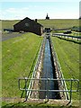
Turbine house at the water treatment works
In July 2009 Castle Carrock celebrated the centenary of the opening of the reservoir and waterworks. BBC Cumbria has a gallery of historic photos taken when it was built - compare this picture (taken on a guided tour) with one taken about 100 years ago : http://www.bbc.co.uk/cumbria/content/image_galleries/castle_carrock_reservoir_20090710_gallery.shtml?41 .
Image: © Rose and Trev Clough
Taken: 11 Jul 2009
0.11 miles
2
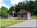
Entrance to Castle Carrock Water Treatment Works
Owned by United Utilities, the works supplies 34,000 customers mainly to the north and east of Carlisle, including Brampton, Longtown and Wetheral.
Image: © Rose and Trev Clough
Taken: 11 Jul 2009
0.11 miles
3
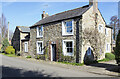
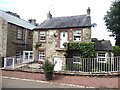
Ralph Cottage, Castle Carrock
The lintel above the doorway of Ralph Cottage names the house and tells that it was built in 1884. Its frontage is fairly small but it appears to have been extended to the rear.
Image: © Trevor Littlewood
Taken: 19 Mar 2022
0.11 miles
4
Castle Carrock Beck, at the Waterworks
The beck has been culverted around the east side of Castle Carrock reservoir - see http://www.geograph.org.uk/photo/1433223 . It emerges behind the dam and is channelled through the water treatment works, after which it continues naturally downstream to join the River Gelt. The grassed slope of the reservoir dam is seen in the distance, with the top of the valve tower http://www.geograph.org.uk/photo/1433206 peeping over the top. (Photo taken on a guided tour of the works, which is not normally open to the public).
Image: © Rose and Trev Clough
Taken: 11 Jul 2009
0.12 miles
5
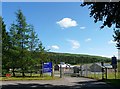
Garth Foot Cottage
Adjacent to Garth Foot Farm.
Image: © Oliver Dixon
Taken: 7 Aug 2020
0.13 miles
6
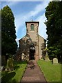
Gravestones and war memorials at St. Peter's Church
Unusually, St. Peter's Church in Castle Carrock has two war memorials; they are on either side of the path leading to the main entrance. The smaller monument to the left has just two names from the Second World War. The taller, Great War memorial, is to the right.
Image: © Trevor Littlewood
Taken: 19 Mar 2022
0.16 miles
7
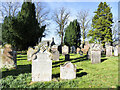
Gravestones in Castle Carrock
Graves in the churchyard of St. Peter on the south side of the church.
Image: © Trevor Littlewood
Taken: 19 Mar 2022
0.16 miles
8
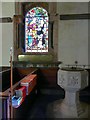
Font and window, St. Peter's Church
The window is in memory of Ann Watson of Holme Eden, who died in 1904.
Image: © Rose and Trev Clough
Taken: 11 Jul 2009
0.16 miles
10
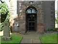
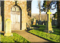
Entrance to St. Peter's Church, Castle Carrock
The stone cross on the grass is a war memorial to James Hetherington and Donald Armstrong, who gave their lives for their country, 1939-1945. Note the arrow-shaped bench mark, lower left stonework of porch.
Image: © Rose and Trev Clough
Taken: 11 Jul 2009
0.17 miles