IMAGES TAKEN NEAR TO
Faugh, Heads Nook, BRAMPTON, CA8 9EG
Introduction
This page details the photographs taken nearby to CA8 9EG by members of the Geograph project.
The Geograph project started in 2005 with the aim of publishing, organising and preserving representative images for every square kilometre of Great Britain, Ireland and the Isle of Man.

There are currently over 7.5m images from over14,400 individuals and you can help contribute to the project by visiting https://www.geograph.org.uk
Image Map
Images are licensed for reuse under creativecommons.org/licenses/by-sa/2.0
Notes
- Clicking on the map will re-center to the selected point.
- The higher the marker number, the further away the image location is from the centre of the postcode.
Image Listing (10 Images Found)
Images are licensed for reuse under creativecommons.org/licenses/by-sa/2.0
Image
Details
Distance
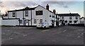
2
Field View Cottages on west side of village road
Ordnance Survey records indicate that a benchmark levelled at 98.428m above Newlyn Datum was verified in 1972 on a cottage at this location
Image: © Luke Shaw
Taken: 26 Jan 2023
0.06 miles
3
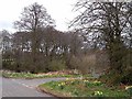
Woodland and farm turning
Scene near Faugh village. Wayside daffodils seem to be a particularly common feature this spring.
Image: © Oliver Dixon
Taken: 4 Apr 2009
0.19 miles
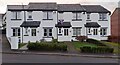
4
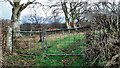
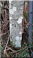
Field gateway on east side of rural road north of Faugh
There is an Ordnance Survey benchmark Image on the inside face of the left hand gatepost of the gateway
Image: © Roger Templeman
Taken: 26 Jan 2023
0.19 miles
5
Benchmark on gatepost at field gateway on east side of road north of Faugh
Ordnance Survey cut mark benchmark levelled at 89.170m above Newlyn Datum verified 1972
Image: © Roger Templeman
Taken: 26 Jan 2023
0.19 miles
7
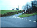
Crossroads at south end of Faugh
In the image are a Cumberland County Council finger signpost Image, a bus shelter and a brick letter box which has an Ordnance Survey benchmark Image at its base.
Image: © Roger Templeman
Taken: 26 Jan 2023
0.20 miles
8
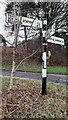
Cumberland County Council finger signpost at cross roads at south end of Faugh
The signpost has Milestone Society National ID: CU_NY5054
Image: © Roger Templeman
Taken: 26 Jan 2023
0.20 miles
9
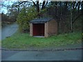
Bus shelter near Moss Knowe
The gates to the left lead to the old Faugh Sand Quarry
Image: © Alexander P Kapp
Taken: 22 Nov 2006
0.20 miles
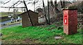
10
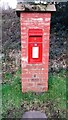
EIIR post box with benchmark at bottom near crossroads south of Faugh
Ordnance Survey cut mark benchmark levelled at 106.241m above Newlyn Datum verified 1972
Image: © Roger Templeman
Taken: 26 Jan 2023
0.21 miles