IMAGES TAKEN NEAR TO
Newbiggin, Heads Nook, BRAMPTON, CA8 9DH
Introduction
This page details the photographs taken nearby to CA8 9DH by members of the Geograph project.
The Geograph project started in 2005 with the aim of publishing, organising and preserving representative images for every square kilometre of Great Britain, Ireland and the Isle of Man.

There are currently over 7.5m images from over14,400 individuals and you can help contribute to the project by visiting https://www.geograph.org.uk
Image Map
Images are licensed for reuse under creativecommons.org/licenses/by-sa/2.0
Notes
- Clicking on the map will re-center to the selected point.
- The higher the marker number, the further away the image location is from the centre of the postcode.
Image Listing (11 Images Found)
Images are licensed for reuse under creativecommons.org/licenses/by-sa/2.0
Image
Details
Distance
2
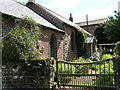
Former chapel, Newbiggin
Formerly a Wesleyan chapel, now a private residence.
Image: © Andrew Smith
Taken: 7 Feb 2006
0.03 miles
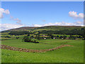
3
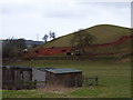
Hillock at Newbiggin
The red soil has been exposed here by erosion.
Image: © Andrew Smith
Taken: 7 Feb 2006
0.06 miles
5
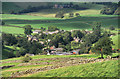
Newbiggin
View of Newbiggin seen from the track leading to Croglin.
Image: © Peter McDermott
Taken: 4 Sep 2011
0.07 miles
6
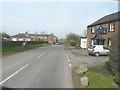
The B6413 through Newbiggin
With the Blue Bell Inn on the right
Image: © John Baker
Taken: 24 Mar 2012
0.16 miles
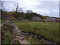
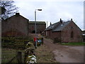
9
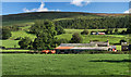
Newbiggin
Townfoot Farm in Newbiggin, beneath the Pennines.
Image: © Peter McDermott
Taken: 4 Sep 2011
0.19 miles
10
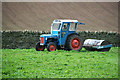
Newbiggin
Ford Dexta being put to work on Townfoot Farm at Newbiggin.
Image: © Peter McDermott
Taken: 2 May 2009
0.20 miles