IMAGES TAKEN NEAR TO
Slaggyford, BRAMPTON, CA8 7NR
Introduction
This page details the photographs taken nearby to CA8 7NR by members of the Geograph project.
The Geograph project started in 2005 with the aim of publishing, organising and preserving representative images for every square kilometre of Great Britain, Ireland and the Isle of Man.

There are currently over 7.5m images from over14,400 individuals and you can help contribute to the project by visiting https://www.geograph.org.uk
Image Map
Images are licensed for reuse under creativecommons.org/licenses/by-sa/2.0
Notes
- Clicking on the map will re-center to the selected point.
- The higher the marker number, the further away the image location is from the centre of the postcode.
Image Listing (13 Images Found)
Images are licensed for reuse under creativecommons.org/licenses/by-sa/2.0
Image
Details
Distance
2
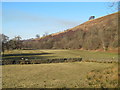
Knarburn Cottage
With fields descending to the River South Tyne.
Image: © Andrew Smith
Taken: 4 Jun 2006
0.06 miles
3
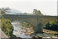
Bridge over Knar Burn off A689 near Knarsdale
View SE, just off the A689 along the valley of the South Tyne River. [Confirmation, please?]
Image: © Ben Brooksbank
Taken: 27 Jun 1986
0.07 miles
4
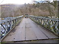
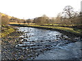
Bailey bridge over the South Tyne crossing from Slaggyford road to Parson Shields
Quite an impressive bit of engineering in an area where stone-built bridges are more the norm for minor roads and farm tracks.
Image: © Andy Waddington
Taken: 13 Mar 2011
0.08 miles
5
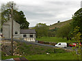
Haugh by the River South Tyne at Parson Shields
Image: © Mike Quinn
Taken: 27 Feb 2013
0.13 miles
6
The River South Tyne south of Parson Shields
Image: © Mike Quinn
Taken: 27 Feb 2013
0.13 miles
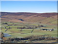
8
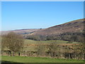
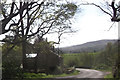
The valley of the River South Tyne around Parson Shields
Photo taken from near the Image
Image: © Mike Quinn
Taken: 27 Feb 2013
0.15 miles
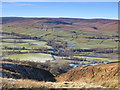
9
The valley of the River South Tyne south of Knarsdale
Image: © Mike Quinn
Taken: 20 Jan 2011
0.16 miles
10

The valley of the River South Tyne around Parson Shields
Shows the location of Image The farm buildings at Parson Shields can just be seen through the trees, right
Image: © Mike Quinn
Taken: 27 Feb 2013
0.16 miles