IMAGES TAKEN NEAR TO
Greenhead, BRAMPTON, CA8 7HZ
Introduction
This page details the photographs taken nearby to CA8 7HZ by members of the Geograph project.
The Geograph project started in 2005 with the aim of publishing, organising and preserving representative images for every square kilometre of Great Britain, Ireland and the Isle of Man.

There are currently over 7.5m images from over14,400 individuals and you can help contribute to the project by visiting https://www.geograph.org.uk
Image Map
Images are licensed for reuse under creativecommons.org/licenses/by-sa/2.0
Notes
- Clicking on the map will re-center to the selected point.
- The higher the marker number, the further away the image location is from the centre of the postcode.
Image Listing (12 Images Found)
Images are licensed for reuse under creativecommons.org/licenses/by-sa/2.0
Image
Details
Distance
3
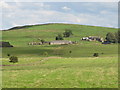
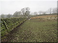
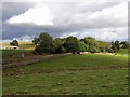
Farmland around Fell End
Shows the location of Image Photo taken from the minor road that runs north from the Military Road towards Carvoran in Image
Image: © Mike Quinn
Taken: 25 Aug 2011
0.05 miles
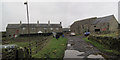
4
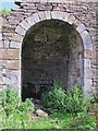
Fell End lime kiln - rightmost arch
See Image Photo taken with the kind permission of the occupant of Fell End.
Image: © Mike Quinn
Taken: 25 Aug 2011
0.07 miles
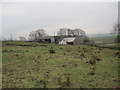
5
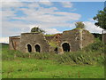
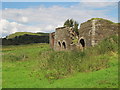
Fell End lime kiln
Magnificent four-arch lime kiln; unfortunately, the second arch from the right has collapsed. Photo taken with the kind permission of the occupant of Fell End.
Image: © Mike Quinn
Taken: 25 Aug 2011
0.08 miles
6
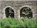
Fell End lime kiln - left hand two arches
See Image Photo taken with the kind permission of the occupant of Fell End.
Image: © Mike Quinn
Taken: 25 Aug 2011
0.08 miles
7
Fell End lime kiln (2)
Looking NNE towards Hadrian's Wall on the ridge above the Image Photo taken with the kind permission of the occupant of Fell End.
Image: © Mike Quinn
Taken: 25 Aug 2011
0.08 miles
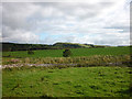
8
Military Road near Fell End
Road running east climbs onto Haltwhistle Common. The farm of Fell End is hidden among the trees.
Image: © Andrew Curtis
Taken: 25 Sep 2015
0.12 miles